Weather Alerts for Montana
1. High Wind Warning for: Madison River Valley
2. High Wind Watch for: Central and Southeast Phillips; Central and Southern Valley; Petroleum; Garfield; Northern Phillips; Southwest Phillips; Northern Valley
3. High Wind Watch for: Daniels; Sheridan; Western Roosevelt; McCone; Richland; Dawson; Prairie; Wibaux; Eastern Roosevelt
4. High Wind Watch for: Eastern Toole and Liberty; Hill County; Northern Blaine County; Western and Central Chouteau County; Bears Paw Mountains and Southern Blaine; Fergus County below 4500ft
5. Red Flag Warning for: Dawson/McCone/Prairie/Richland/Wibaux Counties
6. Red Flag Warning for: Fort Peck Reservation and Daniels/Roosevelt/Sheridan Counties; Northern Valley and Northern Phillips Counties; The Little Rockies; The Lower Missouri River Breaks including the Charles M Russell National Wildlife Refuge; Southern Petroleum and Southern Garfield Counties
7. Winter Storm Warning for: Absaroka/Beartooth Mountains
8. Winter Storm Warning for: Gallatin and Madison County Mountains and Centennial Mountains
9. Winter Storm Watch for: Gallatin Valley
10. Winter Storm Watch for: Judith Basin County and Judith Gap
11. Winter Storm Watch for: Little Belt and Highwood Mountains
12. Winter Weather Advisory for: Bears Paw Mountains and Southern Blaine
13. Winter Weather Advisory for: Big Belt, Bridger and Castle Mountains
14. Winter Weather Advisory for: Bitterroot/Sapphire Mountains
15. Winter Weather Advisory for: Butte/Blackfoot Region
16. Winter Weather Advisory for: East Glacier Park Region; Northern High Plains
17. Winter Weather Advisory for: Fergus County below 4500ft; Snowy and Judith Mountains
18. Winter Weather Advisory for: Potomac/Seeley Lake Region
19. Winter Weather Advisory for: Southern Rocky Mountain Front; Upper Blackfoot and MacDonald Pass; Gates of the Mountains; Elkhorn and Boulder Mountains; Northwest Beaverhead County; Ruby Mountains and Southern Beaverhead Mountains
20. Winter Weather Advisory for: West Glacier Region
Want more detail? Get the Complete 7 Day and Night Detailed Forecast!
Current U.S. National Radar--Current
The Current National Weather Radar is shown below with a UTC Time (subtract 5 hours from UTC to get Eastern Time).

National Weather Forecast--Current
The Current National Weather Forecast and National Weather Map are shown below.

National Weather Forecast for Tomorrow
Tomorrow National Weather Forecast and Tomorrow National Weather Map are show below.

North America Water Vapor (Moisture)
This map shows recent moisture content over North America. Bright and colored areas show high moisture (ie, clouds); brown indicates very little moisture present; black indicates no moisture.

Weather Topic: What are Nimbostratus Clouds?
Home - Education - Cloud Types - Nimbostratus Clouds
 Next Topic: Precipitation
A nimbostratus cloud is similar to a stratus cloud in its formless,
smooth appearance. However, a nimbostratus cloud is darker than a stratus cloud,
because it is thicker.
Unlike a stratus cloud, a nimbostratus cloud typically brings with it the threat
of moderate to heavy precipitation. In some cases, the precipitation may evaporate
before reaching the ground, a phenomenon known as virga.
Next Topic: Precipitation
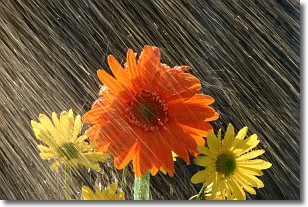
Weather Topic: What is Rain?
Home - Education - Precipitation - Rain
 Next Topic: Shelf Clouds
Precipitation in the form of water droplets is called rain.
Rain generally has a tendency to fall with less intensity over a greater period
of time, and when rainfall is more severe it is usually less sustained.
Rain is the most common form of precipitation and happens with greater frequency
depending on the season and regional influences. Cities have been shown to have
an observable effect on rainfall, due to an effect called the urban heat island.
Compared to upwind, monthly rainfall between twenty and forty miles downwind of
cities is 30% greater.
Next Topic: Shelf Clouds
Current conditions powered by WeatherAPI.com


