Weather Alerts for California
1. Extreme Heat Warning for: Apple and Lucerne Valleys
2. Extreme Heat Warning for: Coachella Valley; San Diego County Deserts; San Gorgonio Pass Near Banning
3. Extreme Heat Warning for: Cuyama Valley; Santa Clarita Valley; Santa Lucia Mountains; Southern Salinas Valley; San Luis Obispo County Interior Valleys; San Luis Obispo County Mountains; Santa Ynez Valley; Santa Barbara County Interior Mountains; Western Santa Monica Mountains Recreational Area; Calabasas and Agoura Hills; Western San Fernando Valley; Eastern San Fernando Valley; Southeastern Ventura County Valleys; Santa Susana Mountains; Southern Ventura County Mountains; Northern Ventura County Mountains; Interstate 5 Corridor; Western San Gabriel Mountains and Highway 14 Corridor; Eastern San Gabriel Mountains; Western Antelope Valley Foothills; Eastern Antelope Valley Foothills; Antelope Valley; Los Angeles County San Gabriel Valley
4. Extreme Heat Warning for: Indian Wells Valley; Mojave Desert Slopes; Mojave Desert
5. Extreme Heat Warning for: Santa Ynez Mountains Western Range; Santa Ynez Mountains Eastern Range; Los Angeles County Inland Coast including Downtown Los Angeles; Eastern Santa Monica Mountains Recreational Area
6. Extreme Heat Warning for: West Side Mountains north of 198; Coalinga - Avenal; Fresno-Clovis; West Side Mountains South of 198; Buena Vista; Bakersfield; South End San Joaquin Valley; Mariposa Madera Foothills; Fresno-Tulare Foothills; South End Sierra Foothills
7. Extreme Heat Warning for: Western Siskiyou County; Central Siskiyou County
8. Heat Advisory for: Lassen-Eastern Plumas-Eastern Sierra Counties
9. Heat Advisory for: Los Banos - Dos Palos; Merced - Madera - Mendota; Planada - Le Grand - Snelling; West Side of Fresno and Kings Counties; Caruthers - San Joaquin - Selma; Buttonwillow - Lost Hills - I5; Delano-Wasco-Shafter; Hanford - Corcoran - Lemoore; Visalia - Porterville - Reedley; Southeast San Joaquin Valley; Kern River Valley
10. Heat Advisory for: North Bay Interior Mountains; East Bay Interior Valleys; Santa Clara Valley Including San Jose; Eastern Santa Clara Hills; East Bay Hills
11. Heat Advisory for: North Bay Interior Valleys; San Francisco Bay Shoreline
12. Heat Advisory for: Northeast Siskiyou and Northwest Modoc Counties; Modoc County; South Central Oregon Cascades; Klamath Basin; Northern and Eastern Klamath County and Western Lake County; Central and Eastern Lake County
13. Heat Advisory for: Northern Humboldt Interior; Southern Humboldt Interior; Northwestern Mendocino Interior; Southeastern Mendocino Interior
14. Heat Advisory for: Northern Trinity; Southern Trinity; Northeastern Mendocino Interior; Northern Lake County; Southern Lake County
15. Heat Advisory for: San Bernardino and Riverside County Valleys-The Inland Empire
16. Heat Advisory for: San Bernardino County Mountains; Riverside County Mountains; San Diego County Mountains
17. Heat Advisory for: San Diego County Inland Valleys
18. Heat Advisory for: San Luis Obispo County Inland Central Coast; Santa Barbara County Inland Central Coast; Lake Casitas; Ojai Valley; Central Ventura County Valleys; Palos Verdes Hills
19. Heat Advisory for: Santa Ana Mountains and Foothills; Orange County Inland
20. Heat Advisory for: Santa Cruz Mountains
21. Heat Advisory for: Shasta Lake Area / Northern Shasta County; Northern Sacramento Valley; Central Sacramento Valley; Southern Sacramento Valley; Carquinez Strait and Delta; Northern San Joaquin Valley; Mountains Southwestern Shasta County to Western Colusa County
22. Heat Advisory for: Southern Salinas Valley/Arroyo Seco and Lake San Antonio; Santa Lucia Mountains and Los Padres National Forest; Mountains Of San Benito County And Interior Monterey County Including Pinnacles National Park
23. Red Flag Warning for: Cuyama Valley; San Luis Obispo County Mountains; Santa Ynez Mountains Western Range; Santa Ynez Mountains Eastern Range; Santa Barbara County Interior Mountains
24. Red Flag Warning for: Fort Tejon
25. Red Flag Warning for: Santa Clarita Valley; Santa Susana Mountains; Southern Ventura County Mountains; Northern Ventura County Mountains; Interstate 5 Corridor; Western San Gabriel Mountains and Highway 14 Corridor; Eastern San Gabriel Mountains; Western Antelope Valley Foothills; Eastern Antelope Valley Foothills
Want more detail? Get the Complete 7 Day and Night Detailed Forecast!
Current U.S. National Radar--Current
The Current National Weather Radar is shown below with a UTC Time (subtract 5 hours from UTC to get Eastern Time).

National Weather Forecast--Current
The Current National Weather Forecast and National Weather Map are shown below.

National Weather Forecast for Tomorrow
Tomorrow National Weather Forecast and Tomorrow National Weather Map are show below.

North America Water Vapor (Moisture)
This map shows recent moisture content over North America. Bright and colored areas show high moisture (ie, clouds); brown indicates very little moisture present; black indicates no moisture.

Weather Topic: What is Precipitation?
Home - Education - Precipitation - Precipitation
 Next Topic: Rain
Precipitation can refer to many different forms of water that
may fall from clouds. Precipitation occurs after a cloud has become saturated to
the point where its water particles are more dense than the air below the cloud.
In most cases, precipitation will reach the ground, but it is not uncommon for
precipitation to evaporate before it reaches the earth's surface.
When precipitation evaporates before it contacts the ground it is called Virga.
Graupel, hail, sleet, rain, drizzle, and snow are forms of precipitation, but fog
and mist are not considered precipitation because the water vapor which
constitutes them isn't dense enough to fall to the ground.
Next Topic: Rain
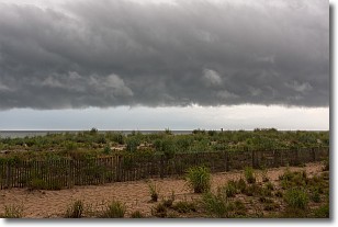
Weather Topic: What are Shelf Clouds?
Home - Education - Cloud Types - Shelf Clouds
 Next Topic: Sleet
A shelf cloud is similar to a wall cloud, but forms at the front
of a storm cloud, instead of at the rear, where wall clouds form.
A shelf cloud is caused by a series of events set into motion by the advancing
storm; first, cool air settles along the ground where precipitation has just fallen.
As the cool air is brought in, the warmer air is displaced, and rises above it,
because it is less dense. When the warmer air reaches the bottom of the storm cloud,
it begins to cool again, and the resulting condensation is a visible shelf cloud.
Next Topic: Sleet
Current conditions powered by WeatherAPI.com


