Weather Alerts for California
1. Beach Hazards Statement for: Santa Barbara County Southwestern Coast; Santa Barbara County Southeastern Coast
2. Coastal Flood Advisory for: Northern Monterey Bay; Southern Monterey Bay and Big Sur Coast
3. Coastal Flood Advisory for: San Francisco; North Bay Interior Valleys; San Francisco Bay Shoreline
4. Flood Watch for: Catalina and Santa Barbara Islands; Santa Clarita Valley; Santa Ynez Valley; Santa Barbara County Southwestern Coast; Santa Barbara County Southeastern Coast; Santa Ynez Mountains Western Range; Santa Ynez Mountains Eastern Range; Santa Barbara County Interior Mountains; Ventura County Beaches; Ventura County Inland Coast; Lake Casitas; Ojai Valley; Central Ventura County Valleys; Malibu Coast; Los Angeles County Beaches; Palos Verdes Hills; Los Angeles County Inland Coast including Downtown Los Angeles; Western Santa Monica Mountains Recreational Area; Eastern Santa Monica Mountains Recreational Area; Calabasas and Agoura Hills; Western San Fernando Valley; Eastern San Fernando Valley; Southeastern Ventura County Valleys; Santa Susana Mountains; Southern Ventura County Mountains; Northern Ventura County Mountains; Interstate 5 Corridor; Western San Gabriel Mountains and Highway 14 Corridor; Eastern San Gabriel Mountains; Los Angeles County San Gabriel Valley; San Miguel and Santa Rosa Islands; Santa Cruz and Anacapa Islands
5. High Surf Advisory for: Malibu Coast; Los Angeles County Beaches
6. High Surf Advisory for: San Diego County Coastal Areas; Orange County Coastal
7. High Surf Advisory for: San Luis Obispo County Beaches; Santa Barbara County Central Coast Beaches
8. High Surf Advisory for: San Luis Obispo County Beaches; Santa Barbara County Central Coast Beaches
9. High Surf Advisory for: Ventura County Beaches
10. High Wind Watch for: Cuyama Valley; San Luis Obispo County Interior Valleys; San Luis Obispo County Mountains; Santa Barbara County Interior Mountains; Southern Ventura County Mountains; Interstate 5 Corridor; Western San Gabriel Mountains and Highway 14 Corridor; Western Antelope Valley Foothills; Eastern Antelope Valley Foothills
11. High Wind Watch for: San Diego County Mountains
12. High Wind Watch for: San Gorgonio Pass Near Banning
13. Wind Advisory for: Apple and Lucerne Valleys
14. Wind Advisory for: Catalina and Santa Barbara Islands; Santa Clarita Valley; San Luis Obispo County Beaches; San Luis Obispo County Inland Central Coast; Santa Lucia Mountains; Southern Salinas Valley; Santa Barbara County Central Coast Beaches; Santa Barbara County Inland Central Coast; Santa Ynez Valley; Santa Barbara County Southwestern Coast; Santa Barbara County Southeastern Coast; Santa Ynez Mountains Western Range; Santa Ynez Mountains Eastern Range; Ventura County Beaches; Ventura County Inland Coast; Lake Casitas; Ojai Valley; Central Ventura County Valleys; Los Angeles County Beaches; Palos Verdes Hills; Los Angeles County Inland Coast including Downtown Los Angeles; Western Santa Monica Mountains Recreational Area; Eastern Santa Monica Mountains Recreational Area; Calabasas and Agoura Hills; Western San Fernando Valley; Eastern San Fernando Valley; Southeastern Ventura County Valleys; Santa Susana Mountains; Antelope Valley; Los Angeles County San Gabriel Valley
15. Wind Advisory for: Imperial County Southwest
16. Wind Advisory for: Joshua Tree NP West; Joshua Tree NP East; Chuckwalla Mountains; Chiriaco Summit; Chuckwalla Valley
17. Wind Advisory for: Northern Sacramento Valley; Central Sacramento Valley; Southern Sacramento Valley
18. Wind Advisory for: San Diego County Coastal Areas; San Bernardino and Riverside County Valleys-The Inland Empire; San Diego County Inland Valleys; Santa Ana Mountains and Foothills; Orange County Coastal; Orange County Inland
19. Wind Advisory for: San Diego County Deserts
20. Wind Advisory for: West Side Mountains north of 198; West Side Mountains South of 198; Buena Vista; Indian Wells Valley; Mojave Desert Slopes; Mojave Desert
21. Winter Storm Warning for: Del Norte Interior; Northern Humboldt Interior; Southern Humboldt Interior
22. Winter Storm Warning for: Eastern Sierra Slopes of Inyo County
23. Winter Storm Warning for: Greater Lake Tahoe Area; Greater Lake Tahoe Area
24. Winter Storm Warning for: Lassen-Eastern Plumas-Eastern Sierra Counties
25. Winter Storm Warning for: Mariposa-Madera Lower Sierra; Fresno-Tulare Lower Sierra; South End of the Lower Sierra; Yosemite NP outside of the valley; Yosemite Valley; San Joaquin River Canyon; Upper San Joaquin River; Kaiser to Rodgers Ridge; Kings Canyon NP; Grant Grove Area; Sequoia NP; South End of the Upper Sierra; Piute Walker Basin
26. Winter Storm Warning for: Mono
27. Winter Storm Warning for: Northern Trinity; Southern Trinity
28. Winter Storm Warning for: Shasta Lake Area / Northern Shasta County; Burney Basin / Eastern Shasta County; Mountains Southwestern Shasta County to Western Colusa County; Northeast Foothills/Sacramento Valley; Motherlode; Western Plumas County/Lassen Park; West Slope Northern Sierra Nevada
29. Winter Storm Warning for: South Central Siskiyou County; North Central and Southeast Siskiyou County
30. Winter Storm Warning for: Tehachapi; Frazier Mountain Communities
31. Winter Storm Warning for: Western Siskiyou County
32. Winter Storm Warning for: White Mountains of Inyo County
33. Winter Storm Watch for: Grapevine
34. Winter Storm Watch for: Northern Ventura County Mountains; Eastern San Gabriel Mountains
35. Winter Storm Watch for: Northwestern Mendocino Interior; Northeastern Mendocino Interior; Northern Lake County; Southern Lake County
36. Winter Storm Watch for: Riverside County Mountains
37. Winter Storm Watch for: San Bernardino County Mountains
38. Winter Storm Watch for: Santa Barbara County Interior Mountains; Southern Ventura County Mountains; Interstate 5 Corridor
Want more detail? Get the Complete 7 Day and Night Detailed Forecast!
Current U.S. National Radar--Current
The Current National Weather Radar is shown below with a UTC Time (subtract 5 hours from UTC to get Eastern Time).

National Weather Forecast--Current
The Current National Weather Forecast and National Weather Map are shown below.

National Weather Forecast for Tomorrow
Tomorrow National Weather Forecast and Tomorrow National Weather Map are show below.

North America Water Vapor (Moisture)
This map shows recent moisture content over North America. Bright and colored areas show high moisture (ie, clouds); brown indicates very little moisture present; black indicates no moisture.

Weather Topic: What are Cirrostratus Clouds?
Home - Education - Cloud Types - Cirrostratus Clouds
 Next Topic: Cirrus Clouds
Cirrostratus clouds are high, thin clouds that form above
20,000 feet and are made mostly of ice crystals. They sometimes look like giant
feathers, horse tails, or curls of hair in the sky.
These clouds are pushed by the jet stream and can move at high speeds reaching
100 mph.
What do they indicate?
They indicate that a precipitation is likely within 24 hours.
Next Topic: Cirrus Clouds
Weather Topic: What is Condensation?
Home - Education - Precipitation - Condensation
 Next Topic: Contrails
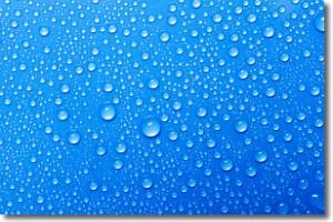
Condensation is the process which creates clouds, and therefore
it is a crucial process in the water cycle.
Condensation is the change of matter from a state of gas into a state of liquid,
and it happens because water molecules release heat into the atmosphere and
become organized into a more closely packed structure, what we might see as
water droplets.
Water is always present in the air around us as a vapor, but it's too small for
us to see. When water undergoes the process of condensation it becomes organized
into visible water droplets. You've probably seen condensation happen before on the
surface of a cold drink!
Next Topic: Contrails
Current conditions powered by WeatherAPI.com


