Weather Alerts for California
1. Beach Hazards Statement for: Coastal Del Norte; Northern Humboldt Coast; Southwestern Humboldt; Mendocino Coast
2. Beach Hazards Statement for: San Francisco; Coastal North Bay Including Point Reyes National Seashore; San Francisco Peninsula Coast; Southern Monterey Bay and Big Sur Coast
3. Dense Fog Advisory for: Los Banos - Dos Palos; Merced - Madera - Mendota; Planada - Le Grand - Snelling; West Side of Fresno and Kings Counties; Caruthers - San Joaquin - Selma; Fresno-Clovis; Buttonwillow - Lost Hills - I5; Delano-Wasco-Shafter; Hanford - Corcoran - Lemoore; Visalia - Porterville - Reedley; Bakersfield; Southeast San Joaquin Valley
4. Wind Advisory for: Northern Sacramento Valley; Central Sacramento Valley; Southern Sacramento Valley
5. Winter Storm Watch for: Del Norte Interior; Northern Humboldt Interior; Southern Humboldt Interior
6. Winter Storm Watch for: Eastern Sierra Slopes of Inyo County
7. Winter Storm Watch for: Greater Lake Tahoe Area; Greater Lake Tahoe Area
8. Winter Storm Watch for: Lassen-Eastern Plumas-Eastern Sierra Counties
9. Winter Storm Watch for: Mariposa-Madera Lower Sierra; Fresno-Tulare Lower Sierra; South End of the Lower Sierra; Yosemite NP outside of the valley; Yosemite Valley; San Joaquin River Canyon; Upper San Joaquin River; Kaiser to Rodgers Ridge; Kings Canyon NP; Grant Grove Area; Sequoia NP; South End of the Upper Sierra; Piute Walker Basin
10. Winter Storm Watch for: Mono
11. Winter Storm Watch for: Northern Trinity; Southern Trinity
12. Winter Storm Watch for: Northwestern Mendocino Interior; Northeastern Mendocino Interior; Northern Lake County; Southern Lake County
13. Winter Storm Watch for: Shasta Lake Area / Northern Shasta County; Burney Basin / Eastern Shasta County; Mountains Southwestern Shasta County to Western Colusa County; Northeast Foothills/Sacramento Valley; Motherlode; Western Plumas County/Lassen Park; West Slope Northern Sierra Nevada
14. Winter Storm Watch for: South Central Siskiyou County; North Central and Southeast Siskiyou County
15. Winter Storm Watch for: South Central Siskiyou County; North Central and Southeast Siskiyou County
16. Winter Storm Watch for: Western Siskiyou County
17. Winter Storm Watch for: Western Siskiyou County
18. Winter Storm Watch for: White Mountains of Inyo County
Want more detail? Get the Complete 7 Day and Night Detailed Forecast!
Current U.S. National Radar--Current
The Current National Weather Radar is shown below with a UTC Time (subtract 5 hours from UTC to get Eastern Time).

National Weather Forecast--Current
The Current National Weather Forecast and National Weather Map are shown below.

National Weather Forecast for Tomorrow
Tomorrow National Weather Forecast and Tomorrow National Weather Map are show below.

North America Water Vapor (Moisture)
This map shows recent moisture content over North America. Bright and colored areas show high moisture (ie, clouds); brown indicates very little moisture present; black indicates no moisture.

Weather Topic: What is Drizzle?
Home - Education - Precipitation - Drizzle
 Next Topic: Evaporation
Drizzle is precipitation in the form of water droplets which are
smaller than raindrops.
Drizzle is characterized by fine, gently falling droplets and typically does not
impact human habitation in a negative way. The exception to this is freezing drizzle,
a condition where drizzle freezes immediately upon reaching earth's surface.
Freezing drizzle is still less dangerous than freezing rain, but can
potentially result in hazardous road conditions.
Next Topic: Evaporation
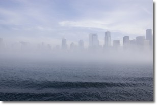
Weather Topic: What is Fog?
Home - Education - Cloud Types - Fog
 Next Topic: Fractus Clouds
Fog is technically a type of stratus cloud, which lies along the
ground and obscures visibility.
It is usually created when humidity in the air condenses into tiny water droplets.
Because of this, some places are more prone to foggy weather, such as regions
close to a body of water.
Fog is similar to mist; both are the appearance of water droplets suspended in
the air, but fog is the term applied to the condition when visibility is less than 1 km.
Next Topic: Fractus Clouds
Current conditions powered by WeatherAPI.com


