Weather Alert in Alaska
Winter Weather Advisory issued August 26 at 10:01PM AKDT until August 28 at 10:00PM AKDT by NWS Fairbanks AK
AREAS AFFECTED: Central Beaufort Sea Coast
DESCRIPTION: * WHAT...Ice accumulations up to 0.05" possible. * WHERE...Central Arctic Plains, Central Beaufort Sea Coast, and Central Brooks Range. * WHEN...Until 10 PM AKDT Thursday. * IMPACTS...Plan on slippery road conditions. Any accumulating snow and freezing rain could create difficult travel conditions. * ADDITIONAL DETAILS...Though uncertainty remains substantial with the incoming storm system, confidence is increasing in light ice accumulations from one, potentially two periods of light freezing rain/freezing drizzle. The first would be Tuesday Night into Wednesday. During this time, precip types are more uncertain as temperatures are expected to hover within a couple degrees of the freezing mark. A second round of light freezing rain appears increasingly likely Thursday into Thursday night. The greatest ice accumulations will be for the Dalton Highway south of Prudhoe Bay, though hazardous driving conditions from icy road conditions will be possible all the way to the northern extent of the highway, especially by Thursday afternoon/evening.
INSTRUCTION: Slow down and use caution while traveling. The latest road conditions for the state you are calling from can be obtained by calling 5 1 1.
Want more detail? Get the Complete 7 Day and Night Detailed Forecast!
Current U.S. National Radar--Current
The Current National Weather Radar is shown below with a UTC Time (subtract 5 hours from UTC to get Eastern Time).

National Weather Forecast--Current
The Current National Weather Forecast and National Weather Map are shown below.

National Weather Forecast for Tomorrow
Tomorrow National Weather Forecast and Tomorrow National Weather Map are show below.

North America Water Vapor (Moisture)
This map shows recent moisture content over North America. Bright and colored areas show high moisture (ie, clouds); brown indicates very little moisture present; black indicates no moisture.

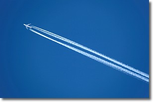
Weather Topic: What are Contrails?
Home - Education - Cloud Types - Contrails
 Next Topic: Cumulonimbus Clouds
A contrail is an artificial cloud, created by the passing of an
aircraft.
Contrails form because water vapor in the exhaust of aircraft engines is suspended
in the air under certain temperatures and humidity conditions. These contrails
are called exhaust contrails.
Another type of contrail can form due to a temporary reduction in air pressure
moving over the plane's surface, causing condensation.
These are called aerodynamic contrails.
When you can see your breath on a cold day, it is also because of condensation.
The reason contrails last longer than the condensation from your breath is
because the water in contrails freezes into ice particles.
Next Topic: Cumulonimbus Clouds
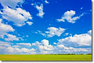
Weather Topic: What are Cumulus Clouds?
Home - Education - Cloud Types - Cumulus Clouds
 Next Topic: Drizzle
Cumulus clouds are fluffy and textured with rounded tops, and
may have flat bottoms. The border of a cumulus cloud
is clearly defined, and can have the appearance of cotton or cauliflower.
Cumulus clouds form at low altitudes (rarely above 2 km) but can grow very tall,
becoming cumulus congestus and possibly the even taller cumulonimbus clouds.
When cumulus clouds become taller, they have a greater chance of producing precipitation.
Next Topic: Drizzle
Current conditions powered by WeatherAPI.com


