Weather Alert in South Carolina
Flood Warning issued August 21 at 10:15AM EDT by NWS Wilmington NC
AREAS AFFECTED: Horry, SC
DESCRIPTION: ...The Flood Warning continues for the following rivers in North Carolina...South Carolina... Lumber River Near Lumberton affecting Robeson County. Waccamaw River At Conway affecting Horry County. * WHAT...Moderate flooding is occurring and moderate flooding is forecast. * WHERE...Waccamaw River at Conway. * WHEN...Until further notice. * IMPACTS...At 12.0 feet, Flooding will worsen in Lees Landing, Riverfront South, Pitch Landing, and Savannah Bluff. Flooding will also worsen along Waccamaw CIR, Riverside DR, and in low areas along Gray Oak DR. Flood waters will begin to affect Black Moss DR and Cypress Flat. Depot RD, New RD, and Jackson Bluff RD may begin to flood. The lowest homes on Riverside DR north of Conway may be affected. Witch Golf Course may begin to flood. Swamps will be heavily flooded. * ADDITIONAL DETAILS... - At 9:15 AM EDT Thursday the stage was 12.3 feet. - Forecast...The river is expected to rise to a crest of 12.3 feet this afternoon. - Flood stage is 11.0 feet. - weather.gov/safety/flood
INSTRUCTION: Stay tuned to further developments by listening to your local radio, television, or NOAA Weather Radio for further information. Turn around, don't drown when encountering flooded roads. Most flood deaths occur in vehicles. Caution is urged when walking near riverbanks. Additional information is available at water.noaa.gov/wfo/ilm . The next statement will be issued by late tonight.
Want more detail? Get the Complete 7 Day and Night Detailed Forecast!
Current U.S. National Radar--Current
The Current National Weather Radar is shown below with a UTC Time (subtract 5 hours from UTC to get Eastern Time).

National Weather Forecast--Current
The Current National Weather Forecast and National Weather Map are shown below.

National Weather Forecast for Tomorrow
Tomorrow National Weather Forecast and Tomorrow National Weather Map are show below.

North America Water Vapor (Moisture)
This map shows recent moisture content over North America. Bright and colored areas show high moisture (ie, clouds); brown indicates very little moisture present; black indicates no moisture.

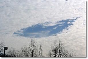
Weather Topic: What are Hole Punch Clouds?
Home - Education - Cloud Types - Hole Punch Clouds
 Next Topic: Mammatus Clouds
A hole punch cloud is an unusual occurrence when a disk-shaped
hole appears in a cirrostratus, cirrocumulus, or altocumulus cloud.
When part of the cloud forms ice crystals, water droplets in the surrounding area
of the cloud evaporate. The effect of this process produces a large elliptical
gap in the cloud. The hole punch cloud formation is rare, but it is not specific
to any geographic area.
Other names which have been used to describe this phenomena include fallstreak hole,
skypunch, and cloud hole.
Next Topic: Mammatus Clouds
Weather Topic: What are Nimbostratus Clouds?
Home - Education - Cloud Types - Nimbostratus Clouds
 Next Topic: Precipitation
A nimbostratus cloud is similar to a stratus cloud in its formless,
smooth appearance. However, a nimbostratus cloud is darker than a stratus cloud,
because it is thicker.
Unlike a stratus cloud, a nimbostratus cloud typically brings with it the threat
of moderate to heavy precipitation. In some cases, the precipitation may evaporate
before reaching the ground, a phenomenon known as virga.
Next Topic: Precipitation
Current conditions powered by WeatherAPI.com


