Weather Alert in Kansas
Red Flag Warning issued February 18 at 1:05PM CST until February 19 at 8:00PM CST by NWS Springfield MO
AREAS AFFECTED: Bourbon; Crawford; Cherokee; Benton; Morgan; Miller; Maries; Vernon; St. Clair; Hickory; Camden; Pulaski; Phelps; Barton; Cedar; Polk; Dallas; Laclede; Texas; Jasper; Dade; Greene; Webster; Wright; Newton; Lawrence; Christian; Douglas; Howell; McDonald; Barry; Stone; Taney; Ozark
DESCRIPTION: The National Weather Service in Springfield has issued a Red Flag Warning, which is in effect from noon to 8 PM CST Thursday. * AFFECTED AREA...Fire Weather Zone 055 Benton, Fire Weather Zone 056 Morgan, Fire Weather Zone 057 Miller, Fire Weather Zone 058 Maries, Fire Weather Zone 066 Vernon, Fire Weather Zone 067 St. Clair, Fire Weather Zone 068 Hickory, Fire Weather Zone 069 Camden, Fire Weather Zone 070 Pulaski, Fire Weather Zone 071 Phelps, Fire Weather Zone 073 Bourbon, Fire Weather Zone 077 Barton, Fire Weather Zone 078 Cedar, Fire Weather Zone 079 Polk, Fire Weather Zone 080 Dallas, Fire Weather Zone 081 Laclede, Fire Weather Zone 082 Texas, Fire Weather Zone 088 Jasper, Fire Weather Zone 089 Dade, Fire Weather Zone 090 Greene, Fire Weather Zone 091 Webster, Fire Weather Zone 092 Wright, Fire Weather Zone 093 Newton, Fire Weather Zone 094 Lawrence, Fire Weather Zone 095 Christian, Fire Weather Zone 096 Douglas, Fire Weather Zone 097 Crawford, Fire Weather Zone 097 Howell, Fire Weather Zone 101 Cherokee, Fire Weather Zone 101 McDonald, Fire Weather Zone 102 Barry, Fire Weather Zone 103 Stone, Fire Weather Zone 104 Taney and Fire Weather Zone 105 Ozark. * TIMING...From noon to 8 PM CST Thursday. * WINDS...West 15 to 25 mph with gusts up to 35 mph. * RELATIVE HUMIDITY...As low as 17 percent. * TEMPERATURES...Up to 72. * IMPACTS...Any fire that develops will catch and spread quickly. Outdoor burning is not recommended.
INSTRUCTION: A Red Flag Warning means that critical fire weather conditions are either occurring now, or will shortly. A combination of strong winds, low relative humidity, and warm temperatures can contribute to extreme fire behavior.
Want more detail? Get the Complete 7 Day and Night Detailed Forecast!
Current U.S. National Radar--Current
The Current National Weather Radar is shown below with a UTC Time (subtract 5 hours from UTC to get Eastern Time).

National Weather Forecast--Current
The Current National Weather Forecast and National Weather Map are shown below.

National Weather Forecast for Tomorrow
Tomorrow National Weather Forecast and Tomorrow National Weather Map are show below.

North America Water Vapor (Moisture)
This map shows recent moisture content over North America. Bright and colored areas show high moisture (ie, clouds); brown indicates very little moisture present; black indicates no moisture.

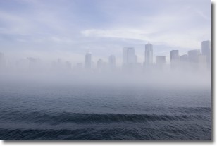
Weather Topic: What is Fog?
Home - Education - Cloud Types - Fog
 Next Topic: Fractus Clouds
Fog is technically a type of stratus cloud, which lies along the
ground and obscures visibility.
It is usually created when humidity in the air condenses into tiny water droplets.
Because of this, some places are more prone to foggy weather, such as regions
close to a body of water.
Fog is similar to mist; both are the appearance of water droplets suspended in
the air, but fog is the term applied to the condition when visibility is less than 1 km.
Next Topic: Fractus Clouds
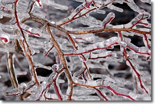
Weather Topic: What is Freezing Rain?
Home - Education - Precipitation - Freezing Rain
 Next Topic: Graupel
Freezing rain is a condition where precipitation which has fallen in the form of
water droplets reaches temperatures which are below freezing and freezes upon
coming into contact
with surface objects. The result of this precipitation is a glaze of ice which
can be damaging to plants and man-made structures. A severe onset of freezing
rain which results in a very thick glaze of ice is known as an ice storm.
Next Topic: Graupel
Current conditions powered by WeatherAPI.com


