Weather Alert in California
Winter Storm Watch issued February 14 at 12:20PM PST until February 19 at 9:00AM PST by NWS Los Angeles/Oxnard CA
AREAS AFFECTED: Northern Ventura County Mountains; Eastern San Gabriel Mountains
DESCRIPTION: * WHAT...Heavy snow possible. Total snow accumulations of 1 to 4 inches for 3500 to 4500 feet elevation possible, 6 to 12 inches for 4500 to 6000 feet elevation possible, and one to two feet above 6000 feet elevation possible. Wind gusts of 60 to 70 mph through Monday afternoon possible, and as high as 50 mph through Thursday morning possible. * WHERE...Eastern San Gabriel Mountains and Northern Ventura County Mountains. * WHEN...From Monday morning through Thursday morning. * IMPACTS...Roads, and especially bridges and overpasses, will likely become slick and hazardous. Travel could become treacherous. Visibilities may drop below one-quarter mile due to falling and blowing snow. Damaging winds could blow down trees and power lines. * ADDITIONAL DETAILS...There will be a break in the snowfall for Tuesday into Tuesday night, before heavy snow returns by Wednesday. However, blowing and drifting snow producing significant visibility restrictions will continue above 6000 feet elevation, even during the break in snowfall.
INSTRUCTION: Monitor the latest forecasts for updates on this situation. If travel is absolutely necessary, drive with extreme caution and be prepared for sudden changes in visibility. Leave plenty of room between you and the motorist ahead of you, and allow extra time to reach your destination. Avoid sudden braking or acceleration, and be especially cautious on hills or when making turns. Make sure your car is winterized and in good working order. Damaging winds could blow down trees and power lines. Travel could be difficult, especially for high profile vehicles.
Want more detail? Get the Complete 7 Day and Night Detailed Forecast!
Current U.S. National Radar--Current
The Current National Weather Radar is shown below with a UTC Time (subtract 5 hours from UTC to get Eastern Time).

National Weather Forecast--Current
The Current National Weather Forecast and National Weather Map are shown below.

National Weather Forecast for Tomorrow
Tomorrow National Weather Forecast and Tomorrow National Weather Map are show below.

North America Water Vapor (Moisture)
This map shows recent moisture content over North America. Bright and colored areas show high moisture (ie, clouds); brown indicates very little moisture present; black indicates no moisture.

Weather Topic: What is Precipitation?
Home - Education - Precipitation - Precipitation
 Next Topic: Rain
Precipitation can refer to many different forms of water that
may fall from clouds. Precipitation occurs after a cloud has become saturated to
the point where its water particles are more dense than the air below the cloud.
In most cases, precipitation will reach the ground, but it is not uncommon for
precipitation to evaporate before it reaches the earth's surface.
When precipitation evaporates before it contacts the ground it is called Virga.
Graupel, hail, sleet, rain, drizzle, and snow are forms of precipitation, but fog
and mist are not considered precipitation because the water vapor which
constitutes them isn't dense enough to fall to the ground.
Next Topic: Rain
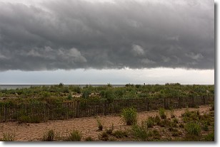
Weather Topic: What are Shelf Clouds?
Home - Education - Cloud Types - Shelf Clouds
 Next Topic: Sleet
A shelf cloud is similar to a wall cloud, but forms at the front
of a storm cloud, instead of at the rear, where wall clouds form.
A shelf cloud is caused by a series of events set into motion by the advancing
storm; first, cool air settles along the ground where precipitation has just fallen.
As the cool air is brought in, the warmer air is displaced, and rises above it,
because it is less dense. When the warmer air reaches the bottom of the storm cloud,
it begins to cool again, and the resulting condensation is a visible shelf cloud.
Next Topic: Sleet
Current conditions powered by WeatherAPI.com


