Weather Alert in California
Winter Weather Advisory issued February 15 at 11:20AM PST until February 19 at 10:00AM PST by NWS Medford OR
AREAS AFFECTED: Northeast Siskiyou and Northwest Modoc Counties; Modoc County; Klamath Basin; Northern and Eastern Klamath County and Western Lake County; Central and Eastern Lake County
DESCRIPTION: ...LOW SNOW LEVELS WITH MULTIPLE ROUNDS OF PRECIPITATION... .A sharp cold front will push through the region Monday night into Tuesday morning with a cold air mass to follow through at least Thursday. Snow levels will quickly lower from around 3000 ft during the day Monday to around 1000-1500 ft late Monday night into the early hours of Tuesday. Multiple waves of precipitation will move through the region while this cold air mass is in place, bringing multiple opportunities for low elevation snow. This will be a long duration event, and after the initial front Monday night, precipitation will become more showery, resulting in periods of spotty and quick accumulations. The values reflected below indicate totals over a 72 hour period from 10pm Monday through 10pm Thursday. Daytime heating will result in snow levels rising to around 2000-2500 ft during the daylight hours, then lower back down during the overnight periods. The best chances for accumulating snow down to valley floors will be during the overnight and early morning hours. * WHAT...Snow expected. Total snow accumulations 2 to 6 inches, with 6 to 10 inches expected across the Modoc, along Highway 97 north of Chiloquin and the higher terrain of the Warners. Winds gusting as high as 40 mph over high and exposed terrain. * WHERE...Klamath Basin and Winter Rim in Klamath county and Lake County, Northeast Siskiyou and Northwest Modoc Counties, and Modoc County. Including the locations of...Dorris, Macdoel, Tulelake, Adin, Alturas, Canby, Day, Likely, Klamath Falls, Olene, Chemult, Crescent, Beatty, Bly, Sprague River, Adel, Fort Rock, Lakeview, Valley Falls, Paisley. This also includes the following passes or notable locations... Cedar Pass on state highway 239 at 6323 ft. Warner Mountain Summit on state highway 140 at 5850 ft. * WHEN...From 4 AM Tuesday to 10 AM PST Thursday. * IMPACTS...Travel may be very difficult to impossible. The hazardous conditions could impact the Tuesday morning and evening commutes. * ADDITIONAL DETAILS...The heaviest snow is expected Monday night into early Tuesday morning. Visit weather.gov/mfr/winter for snow probabilities.
INSTRUCTION: Slow down and use caution while traveling. In California, call 511 or visit quickmap.dot.ca.gov for road information. In Oregon, call 511 or visit tripcheck.com for road information.
Want more detail? Get the Complete 7 Day and Night Detailed Forecast!
Current U.S. National Radar--Current
The Current National Weather Radar is shown below with a UTC Time (subtract 5 hours from UTC to get Eastern Time).

National Weather Forecast--Current
The Current National Weather Forecast and National Weather Map are shown below.

National Weather Forecast for Tomorrow
Tomorrow National Weather Forecast and Tomorrow National Weather Map are show below.

North America Water Vapor (Moisture)
This map shows recent moisture content over North America. Bright and colored areas show high moisture (ie, clouds); brown indicates very little moisture present; black indicates no moisture.

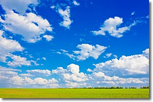
Weather Topic: What are Cumulus Clouds?
Home - Education - Cloud Types - Cumulus Clouds
 Next Topic: Drizzle
Cumulus clouds are fluffy and textured with rounded tops, and
may have flat bottoms. The border of a cumulus cloud
is clearly defined, and can have the appearance of cotton or cauliflower.
Cumulus clouds form at low altitudes (rarely above 2 km) but can grow very tall,
becoming cumulus congestus and possibly the even taller cumulonimbus clouds.
When cumulus clouds become taller, they have a greater chance of producing precipitation.
Next Topic: Drizzle
Weather Topic: What is Evaporation?
Home - Education - Precipitation - Evaporation
 Next Topic: Fog
Evaporation is the process which returns water from the earth
back to the atmosphere, and is another crucial process in the water cycle.
Evaporation is the transformation of liquid into gas, and it happens because
molecules are excited by the application of energy and turn into vapor.
In order for water to evaporate it has to be on the surface of a body of water.
Next Topic: Fog
Current conditions powered by WeatherAPI.com


