Weather Alert in California
Winter Storm Warning issued February 15 at 11:20AM PST until February 19 at 10:00AM PST by NWS Medford OR
AREAS AFFECTED: Western Siskiyou County
DESCRIPTION: ...LOW SNOW LEVELS WITH MULTIPLE ROUNDS OF PRECIPITATION... .A sharp cold front will push through the region Monday night into Tuesday morning with a cold air mass to follow through at least Thursday. Snow levels will quickly lower from around 3000 ft during the day Monday to around 1000-1500 ft late Monday night into the early hours of Tuesday. Multiple waves of precipitation will move through the region while this cold air mass is in place, bringing multiple opportunities for low elevation snow. This will be a long duration event, and after the initial front Monday night, precipitation will become more showery, resulting in periods of spotty and quick accumulations. The values reflected below indicate totals over a 72 hour period from 10pm Monday through 10pm Thursday. Daytime heating will result in snow levels rising to around 2000-2500 ft during the daylight hours, then lower back down during the overnight periods. The best chances for accumulating snow down to valley floors will be during the overnight and early morning hours. * WHAT...Heavy snow expected above 5000 ft through Monday morning with accumulations of 4 to 8 inches expected. After a brief lull in precipitation Monday afternoon, snow levels drop to around 1000-1500 ft Monday night into Tuesday, and remain low through Thursday. Additional snow accumulations 6 to 12 inches are expected with 2 to 3 ft expected above 5000 ft. Winds gusting as high as 40 mph over high and exposed terrain. * WHERE...In western Siskiyou County, elevations above 5000 ft through Monday morning, lowering all areas Monday evening. This includes all of Highway 96 and 3, and Etna Summit on Sawyers Bar Rd. This also now includes the Klamath River and Scott Valleys, the communities of Happy Camp, Somes Bar, Etna, Greenview, and Callahan. * WHEN...Until 10 AM PST Thursday. * IMPACTS...Travel may be very difficult to impossible. The hazardous conditions could impact the Monday morning and evening commutes. * ADDITIONAL DETAILS...The heaviest snow is expected late Monday night into Tuesday morning. Visit weather.gov/mfr/winter for snow probabilities.
INSTRUCTION: If you must travel, keep an extra flashlight, food, and water in your vehicle in case of an emergency. Call 511 or visit quickmap.dot.ca.gov for road information.
Want more detail? Get the Complete 7 Day and Night Detailed Forecast!
Current U.S. National Radar--Current
The Current National Weather Radar is shown below with a UTC Time (subtract 5 hours from UTC to get Eastern Time).

National Weather Forecast--Current
The Current National Weather Forecast and National Weather Map are shown below.

National Weather Forecast for Tomorrow
Tomorrow National Weather Forecast and Tomorrow National Weather Map are show below.

North America Water Vapor (Moisture)
This map shows recent moisture content over North America. Bright and colored areas show high moisture (ie, clouds); brown indicates very little moisture present; black indicates no moisture.

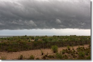
Weather Topic: What are Shelf Clouds?
Home - Education - Cloud Types - Shelf Clouds
 Next Topic: Sleet
A shelf cloud is similar to a wall cloud, but forms at the front
of a storm cloud, instead of at the rear, where wall clouds form.
A shelf cloud is caused by a series of events set into motion by the advancing
storm; first, cool air settles along the ground where precipitation has just fallen.
As the cool air is brought in, the warmer air is displaced, and rises above it,
because it is less dense. When the warmer air reaches the bottom of the storm cloud,
it begins to cool again, and the resulting condensation is a visible shelf cloud.
Next Topic: Sleet
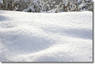
Weather Topic: What is Snow?
Home - Education - Precipitation - Snow
 Next Topic: Stratocumulus Clouds
Snow is precipitation taking the form of ice crystals. Each ice crystal, or snowflake,
has unique characteristics, but all of them grow in a hexagonal structure.
Snowfall can last for sustained periods of time and result in significant buildup
of snow on the ground.
On the earth's surface, snow starts out light and powdery, but as it begins to melt
it tends to become more granular, producing small bits of ice which have the consistency of
sand. After several cycles of melting and freezing, snow can become very dense
and ice-like, commonly known as snow pack.
Next Topic: Stratocumulus Clouds
Current conditions powered by WeatherAPI.com


