Weather Alert in California
Coastal Flood Advisory issued February 15 at 6:24AM PST until February 17 at 3:00PM PST by NWS San Francisco CA
AREAS AFFECTED: San Francisco; North Bay Interior Valleys; San Francisco Bay Shoreline
DESCRIPTION: * WHAT...Up to 1.0 ft of inundation above ground level is possible in low-lying areas near shorelines and tidal waterways. * WHERE...San Francisco Bay Shore. * WHEN...From 7 AM Sunday to 3 PM PST Tuesday. * IMPACTS...Flooding of lots, parks, and roads with only isolated road closures expected. * ADDITIONAL DETAILS...At the San Francisco tidal gauge, high tide is expected to be: 0.9 ft above normal (6.8 ft MLLW) at 9:34 AM Sunday 1.0 ft above normal (6.9 ft MLLW) at 10:16 AM Monday 1.0 ft above normal (6.9 ft MLLW) at 10:58 AM Tuesday These predictions include up to 0.9 ft of storm surge that will enhance the astronomical tide and flooding threat. High tide timing varies up to 90 minutes earlier or later along the Pacific Coast and throughout the San Francisco Bay, respectively.
INSTRUCTION: If travel is required, allow extra time as some roads may be closed. Do not drive around barricades or through water of unknown depth. Take the necessary actions to protect flood-prone property.
Want more detail? Get the Complete 7 Day and Night Detailed Forecast!
Current U.S. National Radar--Current
The Current National Weather Radar is shown below with a UTC Time (subtract 5 hours from UTC to get Eastern Time).

National Weather Forecast--Current
The Current National Weather Forecast and National Weather Map are shown below.

National Weather Forecast for Tomorrow
Tomorrow National Weather Forecast and Tomorrow National Weather Map are show below.

North America Water Vapor (Moisture)
This map shows recent moisture content over North America. Bright and colored areas show high moisture (ie, clouds); brown indicates very little moisture present; black indicates no moisture.

Weather Topic: What is Drizzle?
Home - Education - Precipitation - Drizzle
 Next Topic: Evaporation
Drizzle is precipitation in the form of water droplets which are
smaller than raindrops.
Drizzle is characterized by fine, gently falling droplets and typically does not
impact human habitation in a negative way. The exception to this is freezing drizzle,
a condition where drizzle freezes immediately upon reaching earth's surface.
Freezing drizzle is still less dangerous than freezing rain, but can
potentially result in hazardous road conditions.
Next Topic: Evaporation
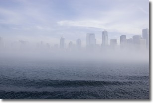
Weather Topic: What is Fog?
Home - Education - Cloud Types - Fog
 Next Topic: Fractus Clouds
Fog is technically a type of stratus cloud, which lies along the
ground and obscures visibility.
It is usually created when humidity in the air condenses into tiny water droplets.
Because of this, some places are more prone to foggy weather, such as regions
close to a body of water.
Fog is similar to mist; both are the appearance of water droplets suspended in
the air, but fog is the term applied to the condition when visibility is less than 1 km.
Next Topic: Fractus Clouds
Current conditions powered by WeatherAPI.com


