Weather Alert in New Mexico
Flash Flood Warning issued August 31 at 12:22PM MDT until August 31 at 2:30PM MDT by NWS El Paso Tx/Santa Teresa NM
AREAS AFFECTED: Grant, NM
DESCRIPTION: FFWEPZ The National Weather Service in El Paso Tx/Santa Teresa has issued a * Flash Flood Warning for... The Trout Fire Burn Scar in... Northeastern Grant County in southwestern New Mexico... * Until 230 PM MDT. * At 1222 PM MDT, Doppler radar indicated thunderstorms producing heavy rain over the Trout Fire Burn Scar. Up to 1 inch of rain has fallen. Additional rainfall amounts up to 1 inch are possible in the warned area. Flash flooding is ongoing or expected to begin shortly. Excessive rainfall over the burn scar will result in debris flow moving through the Trout Fire Burn Scar, into canyons flowing north towards Sapillo Creek, including Hill Canyon and Skates Canyon, and flowing east towards the Mimbres River, including Three Circle, Soldiers, Cottonwood, and Bear Canyons. Sapillo Creek UPSTREAM...or EAST of Lake Roberts Dam, and the upper Mimbres River will also be impacted. The debris flow can consist of rock, mud, vegetation and other loose materials. HAZARD...Life threatening flash flooding. Thunderstorms producing flash flooding in and around the Trout Fire Burn Scar. SOURCE...Radar. IMPACT...Life threatening flash flooding of areas in and around the Trout Fire Burn Scar. * Some locations that will experience flash flooding include... Lake Roberts, San Lorenzo, Allie Canyon, Cottonwood Canyon, Soldiers Canyon, Bear Canyon, Three Circle Canyon, Shingle Canyon, Mimbres River Preserve, Gattons Park, Hill Canyon, Mimbres, Lake Roberts Heights, Camp Thunderbird and Upper Mimbres Valley.
INSTRUCTION: This is a life threatening situation. Heavy rainfall will cause extensive and severe flash flooding of creeks...streams...and ditches in the Trout Fire Burn Scar. Severe debris flows can also be anticipated across roads. Roads and driveways may be washed away in places. If you encounter flood waters...climb to safety.
Want more detail? Get the Complete 7 Day and Night Detailed Forecast!
Current U.S. National Radar--Current
The Current National Weather Radar is shown below with a UTC Time (subtract 5 hours from UTC to get Eastern Time).

National Weather Forecast--Current
The Current National Weather Forecast and National Weather Map are shown below.

National Weather Forecast for Tomorrow
Tomorrow National Weather Forecast and Tomorrow National Weather Map are show below.

North America Water Vapor (Moisture)
This map shows recent moisture content over North America. Bright and colored areas show high moisture (ie, clouds); brown indicates very little moisture present; black indicates no moisture.

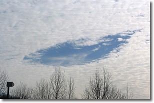
Weather Topic: What are Hole Punch Clouds?
Home - Education - Cloud Types - Hole Punch Clouds
 Next Topic: Mammatus Clouds
A hole punch cloud is an unusual occurrence when a disk-shaped
hole appears in a cirrostratus, cirrocumulus, or altocumulus cloud.
When part of the cloud forms ice crystals, water droplets in the surrounding area
of the cloud evaporate. The effect of this process produces a large elliptical
gap in the cloud. The hole punch cloud formation is rare, but it is not specific
to any geographic area.
Other names which have been used to describe this phenomena include fallstreak hole,
skypunch, and cloud hole.
Next Topic: Mammatus Clouds
Weather Topic: What are Nimbostratus Clouds?
Home - Education - Cloud Types - Nimbostratus Clouds
 Next Topic: Precipitation
A nimbostratus cloud is similar to a stratus cloud in its formless,
smooth appearance. However, a nimbostratus cloud is darker than a stratus cloud,
because it is thicker.
Unlike a stratus cloud, a nimbostratus cloud typically brings with it the threat
of moderate to heavy precipitation. In some cases, the precipitation may evaporate
before reaching the ground, a phenomenon known as virga.
Next Topic: Precipitation
Current conditions powered by WeatherAPI.com


