Weather Alert in Connecticut
Dense Fog Advisory issued March 16 at 4:38PM EDT until March 17 at 1:00AM EDT by NWS Upton NY
AREAS AFFECTED: Southern Fairfield; Southern New Haven; Southern Middlesex; Southern New London; Southern Westchester; Bronx; Kings (Brooklyn); Northwest Suffolk; Northeast Suffolk; Southwest Suffolk; Southeast Suffolk; Northern Queens; Northern Nassau; Southern Queens; Southern Nassau
DESCRIPTION: * WHAT...For the Wind Advisory, south winds 20 to 35 mph with gusts up to 55 mph, shifting west late tonight. Isolated gusts to 60 mph possible. For the Dense Fog Advisory, visibility one quarter mile or less in dense fog. * WHERE...Portions of southern Connecticut and southeast New York. * WHEN...For the Dense Fog Advisory, until 1 AM EDT Tuesday. For the Wind Advisory, until 4 AM EDT Tuesday. * IMPACTS...Gusty winds will blow around unsecured objects. Scattered tree limbs, as well as isolated trees and powerlines could be blown down. Power outages possible. Locally damaging wind gusts in excess of 60 mph are possible with any stronger thunderstorm activity this evening into tonight. This activity will be addressed by Special Weather Statements or Severe Thunderstorm Warnings as needed. Low visibility could make driving conditions hazardous.
INSTRUCTION: Winds this strong can make driving difficult, especially for high profile vehicles. Use extra caution. Secure outdoor objects. If driving, slow down, use your headlights, and leave plenty of distance ahead of you.
Want more detail? Get the Complete 7 Day and Night Detailed Forecast!
Current U.S. National Radar--Current
The Current National Weather Radar is shown below with a UTC Time (subtract 5 hours from UTC to get Eastern Time).

National Weather Forecast--Current
The Current National Weather Forecast and National Weather Map are shown below.

National Weather Forecast for Tomorrow
Tomorrow National Weather Forecast and Tomorrow National Weather Map are show below.

North America Water Vapor (Moisture)
This map shows recent moisture content over North America. Bright and colored areas show high moisture (ie, clouds); brown indicates very little moisture present; black indicates no moisture.

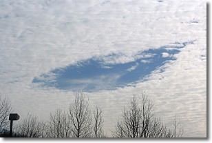
Weather Topic: What are Hole Punch Clouds?
Home - Education - Cloud Types - Hole Punch Clouds
 Next Topic: Mammatus Clouds
A hole punch cloud is an unusual occurrence when a disk-shaped
hole appears in a cirrostratus, cirrocumulus, or altocumulus cloud.
When part of the cloud forms ice crystals, water droplets in the surrounding area
of the cloud evaporate. The effect of this process produces a large elliptical
gap in the cloud. The hole punch cloud formation is rare, but it is not specific
to any geographic area.
Other names which have been used to describe this phenomena include fallstreak hole,
skypunch, and cloud hole.
Next Topic: Mammatus Clouds
Weather Topic: What are Nimbostratus Clouds?
Home - Education - Cloud Types - Nimbostratus Clouds
 Next Topic: Precipitation
A nimbostratus cloud is similar to a stratus cloud in its formless,
smooth appearance. However, a nimbostratus cloud is darker than a stratus cloud,
because it is thicker.
Unlike a stratus cloud, a nimbostratus cloud typically brings with it the threat
of moderate to heavy precipitation. In some cases, the precipitation may evaporate
before reaching the ground, a phenomenon known as virga.
Next Topic: Precipitation
Current conditions powered by WeatherAPI.com


