Weather Alert in Maryland
Tropical Cyclone Statement issued August 21 at 7:47PM EDT by NWS Wakefield VA
AREAS AFFECTED: Dorchester; Wicomico; Somerset; Inland Worcester; Maryland Beaches; Pasquotank; Camden; Western Currituck; Bertie; Chowan; Perquimans; Eastern Currituck; Westmoreland; Richmond; Northumberland; Lancaster; Charles City; New Kent; Gloucester; Middlesex; Mathews; Surry; James City; Isle of Wight; Norfolk/Portsmouth; Suffolk; Chesapeake; Virginia Beach; Accomack; Northampton; Eastern King William; Eastern King and Queen; Eastern Essex; York; Newport News; Hampton/Poquoson
DESCRIPTION: HLSAKQ This product covers CENTRAL AND EASTERN VIRGINIA...NORTHEAST NORTH CAROLINA...AND THE LOWER MARYLAND EASTERN SHORE **ERIN MOVING AWAY FROM THE NORTH CAROLINA COAST** NEW INFORMATION --------------- * CHANGES TO WATCHES AND WARNINGS: - All watches and warnings have been canceled * CURRENT WATCHES AND WARNINGS: - None * STORM INFORMATION: - About 390 miles east-southeast of Ocean City MD or about 440 miles east of Norfolk VA - 36.8N 68.2W - Storm Intensity 100 mph - Movement Northeast or 50 degrees at 20 mph SITUATION OVERVIEW ------------------ Hurricane Erin, currently about 420 miles ENE of Cape Hatteras, NC, continues to move northeast away from the coast. Erin will continue to move northeastward with the center of the storm tracking well offshore of the Mid-Atlantic coast. The tropical storm force wind threat has come to an end for the local area with Erin moving further away. Erin will continue to bring high surf, significant dune and beach erosion and moderate to locally major tidal flooding to the area. Seas of 12 to 18 feet over the coastal waters remain possible this evening into tonight which will allow for significant beach and dune erosion for the coast especially around the times of high tide. In addition, moderate to locally major coastal flooding is expected during the high tide cycle this evening and tonight with inundation of 1 to 3 feet above normally high ground. A Coastal Flood Warning remains in effect for the Atlantic coast from Corolla, NC to Ocean City, MD, areas adjacent to the Chesapeake Bay from Windmill Point south, tidal portions of the James, York, and Rappahannock Rivers as well as adjacent estuaries. A Coastal Flood Warning is also in effect for areas adjacent to the Chesapeake Bay north of Windmill Point through the bay side of the lower Maryland Eastern Shore, and the southern shore of the Potomac River, as well as adjacent estuaries. POTENTIAL IMPACTS ----------------- * SURGE: A Coastal Flood Warning remains in effect for areas along the Atlantic coast, Chesapeake Bay, and tidal rivers. * OTHER COASTAL HAZARDS: Along the Atlantic coast from Fenwick Island Delaware to Duck North Carolina, expect waves to build to 12 to 18 ft today. These large waves combined with increased water levels will likely allow for significant beach and dune erosion. There is a high risk of rip currents along the shoreline through Friday, and a high risk of rip currents will likely continue into the weekend. * WIND: Little to no additional impacts are anticipated at this time. PRECAUTIONARY/PREPAREDNESS ACTIONS ---------------------------------- * EVACUATIONS: Follow the advice of local officials. * OTHER PREPAREDNESS INFORMATION: If you are prone to coastal flooding or ocean overwash be prepared for the possibility of a quick rise in water levels. Closely monitor weather.gov, NOAA Weather Radio and local news outlets for official storm information. Listen for possible changes to the forecast. * ADDITIONAL SOURCES OF INFORMATION: - For information on appropriate preparations see www.readyvirginia.gov, readync.org or mema.maryland.gov - For the latest weather and storm information go to weather.gov/wakefield NEXT UPDATE ----------- As it pertains to this event...this will be the last local statement issued by the National Weather Service in Wakefield VA regarding the effects of tropical cyclone hazards upon the area.
INSTRUCTION: N/A
Want more detail? Get the Complete 7 Day and Night Detailed Forecast!
Current U.S. National Radar--Current
The Current National Weather Radar is shown below with a UTC Time (subtract 5 hours from UTC to get Eastern Time).

National Weather Forecast--Current
The Current National Weather Forecast and National Weather Map are shown below.

National Weather Forecast for Tomorrow
Tomorrow National Weather Forecast and Tomorrow National Weather Map are show below.

North America Water Vapor (Moisture)
This map shows recent moisture content over North America. Bright and colored areas show high moisture (ie, clouds); brown indicates very little moisture present; black indicates no moisture.

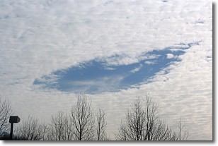
Weather Topic: What are Hole Punch Clouds?
Home - Education - Cloud Types - Hole Punch Clouds
 Next Topic: Mammatus Clouds
A hole punch cloud is an unusual occurrence when a disk-shaped
hole appears in a cirrostratus, cirrocumulus, or altocumulus cloud.
When part of the cloud forms ice crystals, water droplets in the surrounding area
of the cloud evaporate. The effect of this process produces a large elliptical
gap in the cloud. The hole punch cloud formation is rare, but it is not specific
to any geographic area.
Other names which have been used to describe this phenomena include fallstreak hole,
skypunch, and cloud hole.
Next Topic: Mammatus Clouds
Weather Topic: What are Nimbostratus Clouds?
Home - Education - Cloud Types - Nimbostratus Clouds
 Next Topic: Precipitation
A nimbostratus cloud is similar to a stratus cloud in its formless,
smooth appearance. However, a nimbostratus cloud is darker than a stratus cloud,
because it is thicker.
Unlike a stratus cloud, a nimbostratus cloud typically brings with it the threat
of moderate to heavy precipitation. In some cases, the precipitation may evaporate
before reaching the ground, a phenomenon known as virga.
Next Topic: Precipitation
Current conditions powered by WeatherAPI.com


