Weather Alert in California
Flood Warning issued February 25 at 11:52AM PST until February 25 at 4:00PM PST by NWS Eureka CA
AREAS AFFECTED: Mendocino, CA
DESCRIPTION: ...The Flood Warning is extended for the following rivers in California... Navarro River at Navarro affecting Mendocino County. * WHAT...Flooding is currently ongoing. * WHERE...Navarro River at Navarro. * WHEN...Until this afternoon. * ADDITIONAL DETAILS... - At 11:15 AM PST Wednesday the stage was 20.0 feet. - Forecast...The river is expected to fall to 14 feet early Thursday morning. - Flood stage is 23.0 feet. - Flood History...This crest compares to a previous crest of 21.4 feet on 10/24/2021. - http://www.weather.gov/safety/flood
INSTRUCTION: Turn around, don't drown when encountering flooded roads. Most flood deaths occur in vehicles. Motorists should not attempt to drive around barricades or drive cars through flooded areas. Even 6 inches of fast-moving flood water can knock you off your feet and a depth of 2 feet will float your car. Never try to walk, swim, or drive through such deep water. If you come upon flood waters, stop, turn around and go another way. Additional information is available at weather.gov/eka. The next statement will be issued this afternoon at 400 PM PST.
Want more detail? Get the Complete 7 Day and Night Detailed Forecast!
Current U.S. National Radar--Current
The Current National Weather Radar is shown below with a UTC Time (subtract 5 hours from UTC to get Eastern Time).

National Weather Forecast--Current
The Current National Weather Forecast and National Weather Map are shown below.

National Weather Forecast for Tomorrow
Tomorrow National Weather Forecast and Tomorrow National Weather Map are show below.

North America Water Vapor (Moisture)
This map shows recent moisture content over North America. Bright and colored areas show high moisture (ie, clouds); brown indicates very little moisture present; black indicates no moisture.

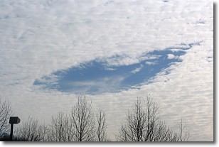
Weather Topic: What are Hole Punch Clouds?
Home - Education - Cloud Types - Hole Punch Clouds
 Next Topic: Mammatus Clouds
A hole punch cloud is an unusual occurrence when a disk-shaped
hole appears in a cirrostratus, cirrocumulus, or altocumulus cloud.
When part of the cloud forms ice crystals, water droplets in the surrounding area
of the cloud evaporate. The effect of this process produces a large elliptical
gap in the cloud. The hole punch cloud formation is rare, but it is not specific
to any geographic area.
Other names which have been used to describe this phenomena include fallstreak hole,
skypunch, and cloud hole.
Next Topic: Mammatus Clouds
Weather Topic: What are Nimbostratus Clouds?
Home - Education - Cloud Types - Nimbostratus Clouds
 Next Topic: Precipitation
A nimbostratus cloud is similar to a stratus cloud in its formless,
smooth appearance. However, a nimbostratus cloud is darker than a stratus cloud,
because it is thicker.
Unlike a stratus cloud, a nimbostratus cloud typically brings with it the threat
of moderate to heavy precipitation. In some cases, the precipitation may evaporate
before reaching the ground, a phenomenon known as virga.
Next Topic: Precipitation
Current conditions powered by WeatherAPI.com


