Weather Alert in South Dakota
Fire Weather Watch issued February 13 at 9:28PM MST until February 15 at 5:00PM MST by NWS Rapid City SD
AREAS AFFECTED: Southern Black Hills; Fall River County Area; Custer County Plains; Pine Ridge Area; Badlands Area; Bennett County Area; Mellette and Todd Counties; Tripp County; Southern Campbell; Weston County Plains
DESCRIPTION: ...CRITICAL FIRE WEATHER CONDITIONS POSSIBLE SUNDAY... .Unseasonably warm weather will combine with very dry air and breezy winds to support potential critical fire weather conditions Sunday. The lowest RH and breeziest winds will be from southern Campbell County east into south central SD. The National Weather Service in Rapid City has issued a Fire Weather Watch for gusty winds and low relative humidity, which is in effect from Sunday morning through Sunday afternoon. * AFFECTED AREA...Fire Weather Zones 315 Southern Campbell, 317 Weston County Plains, 321 Southern Black Hills, 322 Fall River County Area, 325 Custer County Plains, 326 Pine Ridge Area, 332 Badlands Area, 333 Bennett County Area, 334 Mellette and Todd Counties and 335 Tripp County. * WINDS...West 10 to 20 mph with gusts up to 30 mph. * RELATIVE HUMIDITY...As low as 15 percent. * IMPACTS...The combination of gusty winds and low relative humidity would produce critical fire weather conditions.
INSTRUCTION: A Fire Weather Watch means that critical fire weather conditions are forecast to occur. Listen for later forecasts and possible Red Flag Warnings.
Want more detail? Get the Complete 7 Day and Night Detailed Forecast!
Current U.S. National Radar--Current
The Current National Weather Radar is shown below with a UTC Time (subtract 5 hours from UTC to get Eastern Time).

National Weather Forecast--Current
The Current National Weather Forecast and National Weather Map are shown below.

National Weather Forecast for Tomorrow
Tomorrow National Weather Forecast and Tomorrow National Weather Map are show below.

North America Water Vapor (Moisture)
This map shows recent moisture content over North America. Bright and colored areas show high moisture (ie, clouds); brown indicates very little moisture present; black indicates no moisture.

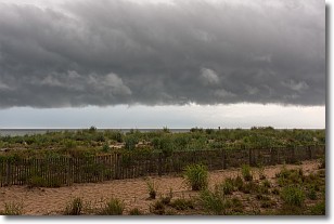
Weather Topic: What are Shelf Clouds?
Home - Education - Cloud Types - Shelf Clouds
 Next Topic: Sleet
A shelf cloud is similar to a wall cloud, but forms at the front
of a storm cloud, instead of at the rear, where wall clouds form.
A shelf cloud is caused by a series of events set into motion by the advancing
storm; first, cool air settles along the ground where precipitation has just fallen.
As the cool air is brought in, the warmer air is displaced, and rises above it,
because it is less dense. When the warmer air reaches the bottom of the storm cloud,
it begins to cool again, and the resulting condensation is a visible shelf cloud.
Next Topic: Sleet
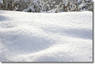
Weather Topic: What is Snow?
Home - Education - Precipitation - Snow
 Next Topic: Stratocumulus Clouds
Snow is precipitation taking the form of ice crystals. Each ice crystal, or snowflake,
has unique characteristics, but all of them grow in a hexagonal structure.
Snowfall can last for sustained periods of time and result in significant buildup
of snow on the ground.
On the earth's surface, snow starts out light and powdery, but as it begins to melt
it tends to become more granular, producing small bits of ice which have the consistency of
sand. After several cycles of melting and freezing, snow can become very dense
and ice-like, commonly known as snow pack.
Next Topic: Stratocumulus Clouds
Current conditions powered by WeatherAPI.com


