Weather Alert in Texas
Special Weather Statement issued March 16 at 3:59PM CDT by NWS Austin/San Antonio TX
AREAS AFFECTED: Llano; Burnet; Williamson; Val Verde; Edwards; Real; Kerr; Bandera; Gillespie; Kendall; Blanco; Hays; Travis; Bastrop; Lee; Kinney; Uvalde; Medina; Bexar; Comal; Guadalupe; Caldwell; Fayette; Maverick; Zavala; Frio; Atascosa; Wilson; Karnes; Gonzales; De Witt; Lavaca; Dimmit
DESCRIPTION: A light freeze with low temperatures mainly between 30 and 32 degrees is forecast Tuesday morning for most of the Hill Country, as well as portions of the I-35 corridor and Coastal Plains, with the aid of light winds and clearing skies. A few of the lowest lying areas may briefly see temperatures of 27 to 30 degrees. Freezing temperatures may set in after midnight before all areas warm above freezing by about 9 AM Tuesday morning. This cold episode could bring challenges as the growing season may have started over portions of the region. Therefore, we recommend to protect Plants, People, and Pets. After Tuesday morning, expect warmer temperatures to prevail through the rest of the week.
INSTRUCTION: N/A
Want more detail? Get the Complete 7 Day and Night Detailed Forecast!
Current U.S. National Radar--Current
The Current National Weather Radar is shown below with a UTC Time (subtract 5 hours from UTC to get Eastern Time).

National Weather Forecast--Current
The Current National Weather Forecast and National Weather Map are shown below.

National Weather Forecast for Tomorrow
Tomorrow National Weather Forecast and Tomorrow National Weather Map are show below.

North America Water Vapor (Moisture)
This map shows recent moisture content over North America. Bright and colored areas show high moisture (ie, clouds); brown indicates very little moisture present; black indicates no moisture.

Weather Topic: What is Sleet?
Home - Education - Precipitation - Sleet
 Next Topic: Snow
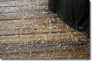
Sleet is a form of precipitation in which small ice pellets are the primary
components. These ice pellets are smaller and more translucent than hailstones,
and harder than graupel. Sleet is caused by specific atmospheric conditions and
therefore typically doesn't last for extended periods of time.
The condition which leads to sleet formation requires a warmer body of air to be
wedged in between two sub-freezing bodies of air. When snow falls through a warmer
layer of air it melts, and as it falls through the next sub-freezing body of air
it freezes again, forming ice pellets known as sleet. In some cases, water
droplets don't have time to freeze before reaching the surface and the result is
freezing rain.
Next Topic: Snow
Weather Topic: What are Stratocumulus Clouds?
Home - Education - Cloud Types - Stratocumulus Clouds
 Next Topic: Stratus Clouds
Stratocumulus clouds are similar to altocumulus clouds in their
fluffy appearance, but have a slightly darker shade due to their additional mass.
A good way to distinguish the two cloud types is to hold your hand out and measure
the size of an individual cloud; if it is the size of your thumb it is generally
an altocumulus cloud, if it is the size of your hand it is generally a
stratocumulus cloud.
It is uncommon for stratocumulus clouds to produce precipitation, but if they do
it is usually a light rain or snow.
Next Topic: Stratus Clouds
Current conditions powered by WeatherAPI.com


