Weather Alert in North Carolina
Severe Thunderstorm Warning issued September 4 at 1:20PM EDT until September 4 at 2:00PM EDT by NWS Blacksburg VA
AREAS AFFECTED: Alleghany, NC; Ashe, NC; Surry, NC; Watauga, NC; Wilkes, NC; Carroll, VA; Grayson, VA; Smyth, VA; Wythe, VA; City of Galax, VA
DESCRIPTION: SVRRNK The National Weather Service in BLACKSBURG has issued a * Severe Thunderstorm Warning for... Alleghany County in northwestern North Carolina... Northwestern Surry County in northwestern North Carolina... Northeastern Wilkes County in northwestern North Carolina... North central Watauga County in northwestern North Carolina... Ashe County in northwestern North Carolina... Southeastern Smyth County in southwestern Virginia... Southern Wythe County in southwestern Virginia... Western Carroll County in southwestern Virginia... The City of Galax in southwestern Virginia... Grayson County in southwestern Virginia... * Until 200 PM EDT. * At 120 PM EDT, a severe thunderstorm was located over Mount Rogers Summit, or 7 miles north of Whitetop, moving east at 55 mph. HAZARD...60 mph wind gusts. SOURCE...Radar indicated. IMPACT...Expect damage to roofs, siding, and trees. * Locations impacted include... Galax... Sparta... Jefferson... West Jefferson... Independence... Fries... and Lansing.
INSTRUCTION: Prepare immediately for damaging winds. For your safety, move to an interior room on the lowest floor of a sturdy building. Stay away from windows. When it is safe to do so, please send your reports of hail of any size, as well as reports of any wind damage, including downed trees or large limbs, to the National Weather Service by calling toll free at 1...8 6 6...2 1 5...4 3 2 4. Reports and pictures can also be shared on the National Weather Service Blacksburg Facebook page and on X.
Want more detail? Get the Complete 7 Day and Night Detailed Forecast!
Current U.S. National Radar--Current
The Current National Weather Radar is shown below with a UTC Time (subtract 5 hours from UTC to get Eastern Time).

National Weather Forecast--Current
The Current National Weather Forecast and National Weather Map are shown below.

National Weather Forecast for Tomorrow
Tomorrow National Weather Forecast and Tomorrow National Weather Map are show below.

North America Water Vapor (Moisture)
This map shows recent moisture content over North America. Bright and colored areas show high moisture (ie, clouds); brown indicates very little moisture present; black indicates no moisture.

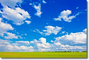
Weather Topic: What are Cumulus Clouds?
Home - Education - Cloud Types - Cumulus Clouds
 Next Topic: Drizzle
Cumulus clouds are fluffy and textured with rounded tops, and
may have flat bottoms. The border of a cumulus cloud
is clearly defined, and can have the appearance of cotton or cauliflower.
Cumulus clouds form at low altitudes (rarely above 2 km) but can grow very tall,
becoming cumulus congestus and possibly the even taller cumulonimbus clouds.
When cumulus clouds become taller, they have a greater chance of producing precipitation.
Next Topic: Drizzle
Weather Topic: What is Evaporation?
Home - Education - Precipitation - Evaporation
 Next Topic: Fog
Evaporation is the process which returns water from the earth
back to the atmosphere, and is another crucial process in the water cycle.
Evaporation is the transformation of liquid into gas, and it happens because
molecules are excited by the application of energy and turn into vapor.
In order for water to evaporate it has to be on the surface of a body of water.
Next Topic: Fog
Current conditions powered by WeatherAPI.com


