Weather Alert in California
Winter Storm Watch issued February 14 at 11:47AM PST until February 19 at 9:00AM PST by NWS San Diego CA
AREAS AFFECTED: Riverside County Mountains
DESCRIPTION: * WHAT...Two rounds of heavy snow possible. For first round Monday, 3-6 inches expected between 6000-7000 ft, 6-12 inches expected above 7000 ft. Winds could gust 60 to 70 mph, with the strongest winds on the desert slopes of the mountains. There may be breaks in snow showers or lighter snow during the day Tuesday, with the next round of heavy snow and gusty winds Wednesday into Thursday morning. * WHERE...Riverside County Mountains. * WHEN...From Monday morning through Thursday morning. * IMPACTS...Roads, and especially bridges and overpasses, will likely become slick and hazardous. Visibilities may drop below 1/4 mile due to falling and blowing snow. Travel could be very difficult to impossible. The hazardous conditions could impact the Monday evening and Tuesday morning commutes. Strong winds could cause tree damage. * ADDITIONAL DETAILS...For the first round Monday, snow levels will start around 6500 ft and fall to near 5000 ft. Lower snow levels possible for the next round Wednesday into Thursday.
INSTRUCTION: Monitor the latest forecasts for updates on this situation.
Want more detail? Get the Complete 7 Day and Night Detailed Forecast!
Current U.S. National Radar--Current
The Current National Weather Radar is shown below with a UTC Time (subtract 5 hours from UTC to get Eastern Time).

National Weather Forecast--Current
The Current National Weather Forecast and National Weather Map are shown below.

National Weather Forecast for Tomorrow
Tomorrow National Weather Forecast and Tomorrow National Weather Map are show below.

North America Water Vapor (Moisture)
This map shows recent moisture content over North America. Bright and colored areas show high moisture (ie, clouds); brown indicates very little moisture present; black indicates no moisture.

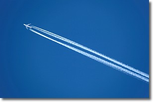
Weather Topic: What are Contrails?
Home - Education - Cloud Types - Contrails
 Next Topic: Cumulonimbus Clouds
A contrail is an artificial cloud, created by the passing of an
aircraft.
Contrails form because water vapor in the exhaust of aircraft engines is suspended
in the air under certain temperatures and humidity conditions. These contrails
are called exhaust contrails.
Another type of contrail can form due to a temporary reduction in air pressure
moving over the plane's surface, causing condensation.
These are called aerodynamic contrails.
When you can see your breath on a cold day, it is also because of condensation.
The reason contrails last longer than the condensation from your breath is
because the water in contrails freezes into ice particles.
Next Topic: Cumulonimbus Clouds
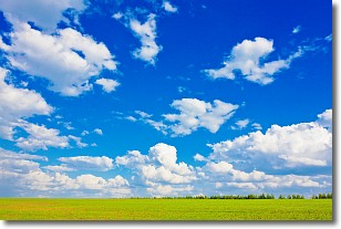
Weather Topic: What are Cumulus Clouds?
Home - Education - Cloud Types - Cumulus Clouds
 Next Topic: Drizzle
Cumulus clouds are fluffy and textured with rounded tops, and
may have flat bottoms. The border of a cumulus cloud
is clearly defined, and can have the appearance of cotton or cauliflower.
Cumulus clouds form at low altitudes (rarely above 2 km) but can grow very tall,
becoming cumulus congestus and possibly the even taller cumulonimbus clouds.
When cumulus clouds become taller, they have a greater chance of producing precipitation.
Next Topic: Drizzle
Current conditions powered by WeatherAPI.com


