Weather Alert in California
Winter Storm Watch issued February 14 at 11:47AM PST until February 19 at 9:00AM PST by NWS San Diego CA
AREAS AFFECTED: San Bernardino County Mountains
DESCRIPTION: * WHAT...Two rounds of heavy snow possible. For first round Monday, 4-9 inches expected between 6000-7000 ft, 9-14 inches expected 7000-8000 ft, and up to 20 inches above 8000 ft. Winds could gust 60 to 70 mph, with the strongest winds on the desert slopes of the mountains. There may be breaks in snow showers or lighter snow during the day Tuesday, with a second round of heavy snow and gusty winds Wednesday into Thursday morning. * WHERE...San Bernardino County Mountains. * WHEN...From Monday morning through Thursday morning. * IMPACTS...Roads, and especially bridges and overpasses, will likely become slick and hazardous. Visibilities may drop below 1/4 mile due to falling and blowing snow. Travel could be very difficult to impossible. The hazardous conditions could impact the Monday morning and evening commutes. Strong winds could cause tree damage. * ADDITIONAL DETAILS...For the first round Monday, snow levels will start around 6500 ft and fall to near 5000 ft. Lower snow levels possible for the next round on Wednesday.
INSTRUCTION: Monitor the latest forecasts for updates on this situation.
Want more detail? Get the Complete 7 Day and Night Detailed Forecast!
Current U.S. National Radar--Current
The Current National Weather Radar is shown below with a UTC Time (subtract 5 hours from UTC to get Eastern Time).

National Weather Forecast--Current
The Current National Weather Forecast and National Weather Map are shown below.

National Weather Forecast for Tomorrow
Tomorrow National Weather Forecast and Tomorrow National Weather Map are show below.

North America Water Vapor (Moisture)
This map shows recent moisture content over North America. Bright and colored areas show high moisture (ie, clouds); brown indicates very little moisture present; black indicates no moisture.

Weather Topic: What are Nimbostratus Clouds?
Home - Education - Cloud Types - Nimbostratus Clouds
 Next Topic: Precipitation
A nimbostratus cloud is similar to a stratus cloud in its formless,
smooth appearance. However, a nimbostratus cloud is darker than a stratus cloud,
because it is thicker.
Unlike a stratus cloud, a nimbostratus cloud typically brings with it the threat
of moderate to heavy precipitation. In some cases, the precipitation may evaporate
before reaching the ground, a phenomenon known as virga.
Next Topic: Precipitation
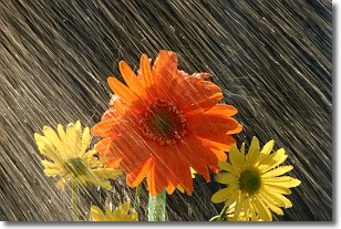
Weather Topic: What is Rain?
Home - Education - Precipitation - Rain
 Next Topic: Shelf Clouds
Precipitation in the form of water droplets is called rain.
Rain generally has a tendency to fall with less intensity over a greater period
of time, and when rainfall is more severe it is usually less sustained.
Rain is the most common form of precipitation and happens with greater frequency
depending on the season and regional influences. Cities have been shown to have
an observable effect on rainfall, due to an effect called the urban heat island.
Compared to upwind, monthly rainfall between twenty and forty miles downwind of
cities is 30% greater.
Next Topic: Shelf Clouds
Current conditions powered by WeatherAPI.com


