Weather Alert in California
Winter Storm Warning issued February 15 at 9:39AM PST until February 18 at 4:00PM PST by NWS Eureka CA
AREAS AFFECTED: Northern Trinity; Southern Trinity
DESCRIPTION: * WHAT...Heavy snow expected for elevations above 5000 feet through Monday, then above 2000 feet Monday night. Total snow accumulation between 5 to 10 inches possible above 2000 feet. Total snow accumulations between 1 and 2.5 feet possible for elevations above 3000 feet. Winds gusting as high as 35 mph. * WHERE...Trinity County. * WHEN...Until 4 PM PST Wednesday. * IMPACTS...Travel could be very difficult to impossible. Tire chains may be necessary if travelling through mountain passes. * ADDITIONAL DETAILS...Snow levels will remain above 5000 to 4500 feet Sunday through Monday, dropping to 2000 feet Monday night into Tuesday. There is a potential for snow levels as low as 1500 feet with the heaviest snowfall. The heaviest snowfall rates are expected late Monday through Tuesday morning.
INSTRUCTION: If you must travel, keep an extra flashlight, food, and water in your vehicle in case of an emergency. The latest road conditions for the state you are calling from can be obtained by calling 5 1 1.
Want more detail? Get the Complete 7 Day and Night Detailed Forecast!
Current U.S. National Radar--Current
The Current National Weather Radar is shown below with a UTC Time (subtract 5 hours from UTC to get Eastern Time).

National Weather Forecast--Current
The Current National Weather Forecast and National Weather Map are shown below.

National Weather Forecast for Tomorrow
Tomorrow National Weather Forecast and Tomorrow National Weather Map are show below.

North America Water Vapor (Moisture)
This map shows recent moisture content over North America. Bright and colored areas show high moisture (ie, clouds); brown indicates very little moisture present; black indicates no moisture.

Weather Topic: What is Drizzle?
Home - Education - Precipitation - Drizzle
 Next Topic: Evaporation
Drizzle is precipitation in the form of water droplets which are
smaller than raindrops.
Drizzle is characterized by fine, gently falling droplets and typically does not
impact human habitation in a negative way. The exception to this is freezing drizzle,
a condition where drizzle freezes immediately upon reaching earth's surface.
Freezing drizzle is still less dangerous than freezing rain, but can
potentially result in hazardous road conditions.
Next Topic: Evaporation
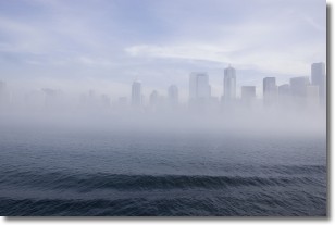
Weather Topic: What is Fog?
Home - Education - Cloud Types - Fog
 Next Topic: Fractus Clouds
Fog is technically a type of stratus cloud, which lies along the
ground and obscures visibility.
It is usually created when humidity in the air condenses into tiny water droplets.
Because of this, some places are more prone to foggy weather, such as regions
close to a body of water.
Fog is similar to mist; both are the appearance of water droplets suspended in
the air, but fog is the term applied to the condition when visibility is less than 1 km.
Next Topic: Fractus Clouds
Current conditions powered by WeatherAPI.com


