Weather Alert in Colorado
Fire Weather Watch issued February 13 at 12:30PM MST until February 17 at 8:00PM MST by NWS Denver CO
AREAS AFFECTED: Larimer and Boulder Counties Between 6000 and 9000 Feet; Larimer County Below 6000 Feet/Northwest Weld County; Boulder And Jefferson Counties Below 6000 Feet/West Broomfield County; Northeast Weld County; Central and South Weld County; Logan County; Sedgwick County; Phillips County
DESCRIPTION: ...PROLONGED PERIOD OF CRITICAL FIRE WEATHER CONDITIONS EARLY TO MID NEXT WEEK... .Recent dry conditions combining with above normal temperatures and much stronger winds early next week will bring potentially critical fire weather conditions Monday and Tuesday, possibly lasting into Wednesday. There is potential for extreme fire weather conditions on Tuesday as widespread strong and gusty winds to around 60 mph are expected. The National Weather Service in Denver has issued a Fire Weather Watch for wind and low relative humidity, which is in effect from Tuesday morning through Tuesday evening. * AFFECTED AREA...Fire Weather Zones 215, 238, 239, 242, 243, 248, 250 and 251. * TIMING...From Tuesday morning through Tuesday evening. * WINDS...West 30 to 40 mph with gusts around 60 mph. * RELATIVE HUMIDITY...As low as 13 percent. * IMPACTS...Conditions will be favorable for rapid fire spread. Avoid outdoor burning and any activity that may produce a spark and start a wildfire. There is potential for extreme fire weather conditions on Tuesday.
INSTRUCTION: A Fire Weather Watch means that critical fire weather conditions are forecast to occur. Listen for later forecasts and possible Red Flag Warnings.
Want more detail? Get the Complete 7 Day and Night Detailed Forecast!
Current U.S. National Radar--Current
The Current National Weather Radar is shown below with a UTC Time (subtract 5 hours from UTC to get Eastern Time).

National Weather Forecast--Current
The Current National Weather Forecast and National Weather Map are shown below.

National Weather Forecast for Tomorrow
Tomorrow National Weather Forecast and Tomorrow National Weather Map are show below.

North America Water Vapor (Moisture)
This map shows recent moisture content over North America. Bright and colored areas show high moisture (ie, clouds); brown indicates very little moisture present; black indicates no moisture.

Weather Topic: What is Precipitation?
Home - Education - Precipitation - Precipitation
 Next Topic: Rain
Precipitation can refer to many different forms of water that
may fall from clouds. Precipitation occurs after a cloud has become saturated to
the point where its water particles are more dense than the air below the cloud.
In most cases, precipitation will reach the ground, but it is not uncommon for
precipitation to evaporate before it reaches the earth's surface.
When precipitation evaporates before it contacts the ground it is called Virga.
Graupel, hail, sleet, rain, drizzle, and snow are forms of precipitation, but fog
and mist are not considered precipitation because the water vapor which
constitutes them isn't dense enough to fall to the ground.
Next Topic: Rain
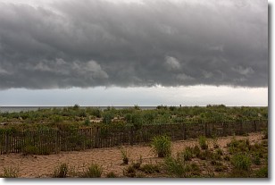
Weather Topic: What are Shelf Clouds?
Home - Education - Cloud Types - Shelf Clouds
 Next Topic: Sleet
A shelf cloud is similar to a wall cloud, but forms at the front
of a storm cloud, instead of at the rear, where wall clouds form.
A shelf cloud is caused by a series of events set into motion by the advancing
storm; first, cool air settles along the ground where precipitation has just fallen.
As the cool air is brought in, the warmer air is displaced, and rises above it,
because it is less dense. When the warmer air reaches the bottom of the storm cloud,
it begins to cool again, and the resulting condensation is a visible shelf cloud.
Next Topic: Sleet
Current conditions powered by WeatherAPI.com


