Weather Alert in Colorado
Fire Weather Watch issued February 13 at 12:30PM MST until February 17 at 8:00PM MST by NWS Denver CO
AREAS AFFECTED: Jefferson and West Douglas Counties Above 6000 Feet/Gilpin/Clear Creek/Northeast Park Counties Below 9000 Feet; North Douglas County Below 6000 Feet/Denver/West Adams and Arapahoe Counties/East Broomfield County; Elbert/Central and East Douglas Counties Above 6000 Feet; Morgan County; Central and East Adams and Arapahoe Counties; North and Northeast Elbert County Below 6000 Feet/North Lincoln County; Southeast Elbert County Below 6000 Feet/South Lincoln County; Washington County
DESCRIPTION: ...PROLONGED PERIOD OF CRITICAL FIRE WEATHER CONDITIONS EARLY TO MID NEXT WEEK... .Recent dry conditions combining with above normal temperatures and much stronger winds early next week will bring potentially critical fire weather conditions Monday and Tuesday, possibly lasting into Wednesday. There is potential for extreme fire weather conditions on Tuesday as widespread strong and gusty winds to around 60 mph are expected. The National Weather Service in Denver has issued a Fire Weather Watch for wind and low relative humidity, which is in effect from Monday morning through Monday afternoon. A Fire Weather Watch has also been issued from Tuesday morning through Tuesday evening. * AFFECTED AREA...Fire Weather Zones 216, 240, 241, 244, 245, 246, 247 and 249. * TIMING...For the first Fire Weather Watch, from late Monday morning through Monday afternoon. For the second Fire Weather Watch, from Tuesday morning through Tuesday evening. * WINDS...Southwest 15 to 25 mph with gusts to 35 mph on Monday. On Tuesday, west winds 30 to 40 mph with gusts around 60 mph. * RELATIVE HUMIDITY...As low as 11 percent. * IMPACTS...Conditions will be favorable for rapid fire spread. Avoid outdoor burning and any activity that may produce a spark and start a wildfire. There is potential for extreme fire weather conditions on Tuesday.
INSTRUCTION: A Fire Weather Watch means that critical fire weather conditions are forecast to occur. Listen for later forecasts and possible Red Flag Warnings.
Want more detail? Get the Complete 7 Day and Night Detailed Forecast!
Current U.S. National Radar--Current
The Current National Weather Radar is shown below with a UTC Time (subtract 5 hours from UTC to get Eastern Time).

National Weather Forecast--Current
The Current National Weather Forecast and National Weather Map are shown below.

National Weather Forecast for Tomorrow
Tomorrow National Weather Forecast and Tomorrow National Weather Map are show below.

North America Water Vapor (Moisture)
This map shows recent moisture content over North America. Bright and colored areas show high moisture (ie, clouds); brown indicates very little moisture present; black indicates no moisture.

Weather Topic: What is Snow?
Home - Education - Precipitation - Snow
 Next Topic: Stratocumulus Clouds
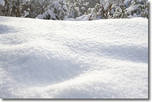
Snow is precipitation taking the form of ice crystals. Each ice crystal, or snowflake,
has unique characteristics, but all of them grow in a hexagonal structure.
Snowfall can last for sustained periods of time and result in significant buildup
of snow on the ground.
On the earth's surface, snow starts out light and powdery, but as it begins to melt
it tends to become more granular, producing small bits of ice which have the consistency of
sand. After several cycles of melting and freezing, snow can become very dense
and ice-like, commonly known as snow pack.
Next Topic: Stratocumulus Clouds
Weather Topic: What are Stratus Clouds?
Home - Education - Cloud Types - Stratus Clouds
 Next Topic: Wall Clouds
Stratus clouds are similar to altostratus clouds, but form at a
lower altitude and are identified by their fog-like appearance, lacking the
distinguishing features of most clouds.
Stratus clouds are wider than most clouds, and their base has a smooth, uniform
look which is lighter in color than a nimbostratus cloud.
The presence of a stratus cloud indicates the possibility of minor precipitation,
such as drizzle, but heavier precipitation does not typically arrive in the form
of a stratus cloud.
Next Topic: Wall Clouds
Current conditions powered by WeatherAPI.com


