Weather Alert in Oregon
Winter Weather Advisory issued February 19 at 12:25AM PST until February 19 at 10:00AM PST by NWS Medford OR
AREAS AFFECTED: Eastern Douglas County Foothills; South Central Oregon Cascades; Siskiyou Mountains and Southern Oregon Cascades
DESCRIPTION: * WHAT...Snow. Additional snow accumulations 3 to 10 inches. Around 3 to 5 inches is expected for Siskiyou Summit and along Highway 138, with highest amounts in the Cascades. A majority of the snow is expected from 2 AM PST to 9 AM PST this morning, with light snow showers then tapering off through the day. * WHERE...The southern Oregon Cascades and Siskiyou Mountains, and Eastern Douglas County Foothills. Including the locations of...Toketee Falls, Steamboat, Crescent Lake, Diamond Lake, Union Creek, Howard Prairie. This also includes the following passes or notable locations... Siskiyou Pass on I-5 at 4310 ft. Lake of the Woods on 140 at 5070 ft. Diamond Lake Junction on state highways 230 & 138 at 4478 ft. Mt. Ashland ski road and lodge at 6500 ft. Caves National Monument near highway 46 at 4000 ft. Willamette Pass on state highway 58 at 5090 ft. * WHEN...Until 10 AM PST this morning. * IMPACTS...Plan on slippery road conditions and delays in your commute. * ADDITIONAL DETAILS...Visit weather.gov/mfr/winter for additional snow probabilities
INSTRUCTION: Slow down and use caution while traveling. Call 511 or visit tripcheck.com for road information.
Want more detail? Get the Complete 7 Day and Night Detailed Forecast!
Current U.S. National Radar--Current
The Current National Weather Radar is shown below with a UTC Time (subtract 5 hours from UTC to get Eastern Time).

National Weather Forecast--Current
The Current National Weather Forecast and National Weather Map are shown below.

National Weather Forecast for Tomorrow
Tomorrow National Weather Forecast and Tomorrow National Weather Map are show below.

North America Water Vapor (Moisture)
This map shows recent moisture content over North America. Bright and colored areas show high moisture (ie, clouds); brown indicates very little moisture present; black indicates no moisture.

Weather Topic: What is Precipitation?
Home - Education - Precipitation - Precipitation
 Next Topic: Rain
Precipitation can refer to many different forms of water that
may fall from clouds. Precipitation occurs after a cloud has become saturated to
the point where its water particles are more dense than the air below the cloud.
In most cases, precipitation will reach the ground, but it is not uncommon for
precipitation to evaporate before it reaches the earth's surface.
When precipitation evaporates before it contacts the ground it is called Virga.
Graupel, hail, sleet, rain, drizzle, and snow are forms of precipitation, but fog
and mist are not considered precipitation because the water vapor which
constitutes them isn't dense enough to fall to the ground.
Next Topic: Rain
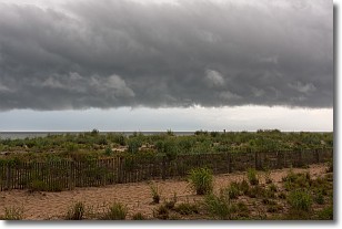
Weather Topic: What are Shelf Clouds?
Home - Education - Cloud Types - Shelf Clouds
 Next Topic: Sleet
A shelf cloud is similar to a wall cloud, but forms at the front
of a storm cloud, instead of at the rear, where wall clouds form.
A shelf cloud is caused by a series of events set into motion by the advancing
storm; first, cool air settles along the ground where precipitation has just fallen.
As the cool air is brought in, the warmer air is displaced, and rises above it,
because it is less dense. When the warmer air reaches the bottom of the storm cloud,
it begins to cool again, and the resulting condensation is a visible shelf cloud.
Next Topic: Sleet
Current conditions powered by WeatherAPI.com


