Weather Alert in Oregon
Winter Storm Warning issued February 19 at 12:25AM PST until February 19 at 10:00AM PST by NWS Medford OR
AREAS AFFECTED: Jackson County
DESCRIPTION: * WHAT...For the Winter Storm Warning above 2000 ft, heavy snow. Additional snow accumulations 2 to 6 inches. For the Winter Weather Advisory below 2000 ft, snow. Additional snow accumulations 1 to 3 inches. Snow levels near 2000 feet will fall to valley floors tonight. The majority of snow is expected between 2 AM PST and 7 AM PST this morning, with light snow showers then tapering off by 10 AM PST. * WHERE...For the Winter Weather Advisory below 2000 ft, this includes Medford, Ashland, Gold Hill, Jacksonville, Applegate, Shady Cove and Eagle Point. This also includes portions of I-5 and Highways 140, 238, 62 and 234. For the Winter Storm Warning, this includes Prospect and Butte Falls. This also includes portions of I-5, Highways 140, 238, 62 and 227, and includes Jacksonville Hill on State Highway 238 at 2150 ft. * WHEN...Until 10 AM PST this morning. * IMPACTS...Plan on slippery road conditions and delays in your commute. * ADDITIONAL DETAILS...Visit weather.gov/mfr/winter for additional snow probabilities
INSTRUCTION: If you must travel, keep an extra flashlight, food, and water in your vehicle in case of an emergency. Call 511 or visit tripcheck.com for road information. Slow down and use caution while traveling. Call 511 or visit tripcheck.com for road information.
Want more detail? Get the Complete 7 Day and Night Detailed Forecast!
Current U.S. National Radar--Current
The Current National Weather Radar is shown below with a UTC Time (subtract 5 hours from UTC to get Eastern Time).

National Weather Forecast--Current
The Current National Weather Forecast and National Weather Map are shown below.

National Weather Forecast for Tomorrow
Tomorrow National Weather Forecast and Tomorrow National Weather Map are show below.

North America Water Vapor (Moisture)
This map shows recent moisture content over North America. Bright and colored areas show high moisture (ie, clouds); brown indicates very little moisture present; black indicates no moisture.

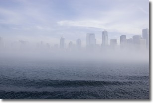
Weather Topic: What is Fog?
Home - Education - Cloud Types - Fog
 Next Topic: Fractus Clouds
Fog is technically a type of stratus cloud, which lies along the
ground and obscures visibility.
It is usually created when humidity in the air condenses into tiny water droplets.
Because of this, some places are more prone to foggy weather, such as regions
close to a body of water.
Fog is similar to mist; both are the appearance of water droplets suspended in
the air, but fog is the term applied to the condition when visibility is less than 1 km.
Next Topic: Fractus Clouds
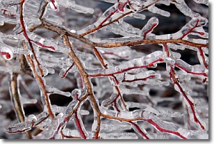
Weather Topic: What is Freezing Rain?
Home - Education - Precipitation - Freezing Rain
 Next Topic: Graupel
Freezing rain is a condition where precipitation which has fallen in the form of
water droplets reaches temperatures which are below freezing and freezes upon
coming into contact
with surface objects. The result of this precipitation is a glaze of ice which
can be damaging to plants and man-made structures. A severe onset of freezing
rain which results in a very thick glaze of ice is known as an ice storm.
Next Topic: Graupel
Current conditions powered by WeatherAPI.com


