Weather Alert in Oregon
Winter Weather Advisory issued February 19 at 12:25AM PST until February 19 at 10:00AM PST by NWS Medford OR
AREAS AFFECTED: Eastern Curry County and Josephine County
DESCRIPTION: * WHAT...For the Winter Storm Warning above 1500 ft, heavy snow. Additional snow accumulations 4 to 8 inches, except 8 to 16 inches in the Kalmiopsis Wilderness. For the Winter Weather Advisory below 1500 ft, wet snow. Additional snow accumulations 1 to 5 inches, highest amounts in the Illinois Valley while Grants Pass is expected to receive mixed precipitation to an inch of snow. The majority of snow is expected through 5 AM PST today, with snow tapering off by 10 AM PST. * WHERE...For the Winter Weather Advisory below 1500 ft, this includes Grants Pass, Wilderville, Merlin, Galice and Agness as well as portions of I-5 and Highway 199. For the Winter Storm Warning above 1500 ft, this includes Cave Junction, Obrien, Selma and Wolf Creek. This also includes portions of I-5 and Highway 199 and the Sexton Pass, Smith Hill and Stage Pass on I-5, Hayes Hill on Highway 199 and Bear Camp road in the Kalmiopsis Wilderness. * WHEN...Until 10 AM PST this morning. * IMPACTS...Travel may be very difficult to impossible, especially at higher elevations. The hazardous conditions could impact the morning commute. * ADDITIONAL DETAILS...Visit weather.gov/mfr/winter for additional snow probabilities
INSTRUCTION: If you must travel, keep an extra flashlight, food, and water in your vehicle in case of an emergency. Call 511 or visit tripcheck.com for road information. Slow down and use caution while traveling. Call 511 or visit tripcheck.com for road information.
Want more detail? Get the Complete 7 Day and Night Detailed Forecast!
Current U.S. National Radar--Current
The Current National Weather Radar is shown below with a UTC Time (subtract 5 hours from UTC to get Eastern Time).

National Weather Forecast--Current
The Current National Weather Forecast and National Weather Map are shown below.

National Weather Forecast for Tomorrow
Tomorrow National Weather Forecast and Tomorrow National Weather Map are show below.

North America Water Vapor (Moisture)
This map shows recent moisture content over North America. Bright and colored areas show high moisture (ie, clouds); brown indicates very little moisture present; black indicates no moisture.

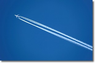
Weather Topic: What are Contrails?
Home - Education - Cloud Types - Contrails
 Next Topic: Cumulonimbus Clouds
A contrail is an artificial cloud, created by the passing of an
aircraft.
Contrails form because water vapor in the exhaust of aircraft engines is suspended
in the air under certain temperatures and humidity conditions. These contrails
are called exhaust contrails.
Another type of contrail can form due to a temporary reduction in air pressure
moving over the plane's surface, causing condensation.
These are called aerodynamic contrails.
When you can see your breath on a cold day, it is also because of condensation.
The reason contrails last longer than the condensation from your breath is
because the water in contrails freezes into ice particles.
Next Topic: Cumulonimbus Clouds
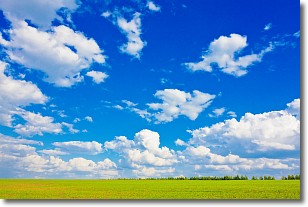
Weather Topic: What are Cumulus Clouds?
Home - Education - Cloud Types - Cumulus Clouds
 Next Topic: Drizzle
Cumulus clouds are fluffy and textured with rounded tops, and
may have flat bottoms. The border of a cumulus cloud
is clearly defined, and can have the appearance of cotton or cauliflower.
Cumulus clouds form at low altitudes (rarely above 2 km) but can grow very tall,
becoming cumulus congestus and possibly the even taller cumulonimbus clouds.
When cumulus clouds become taller, they have a greater chance of producing precipitation.
Next Topic: Drizzle
Current conditions powered by WeatherAPI.com


