Weather Alert in New Mexico
Flood Watch issued August 26 at 11:10AM MDT until August 27 at 12:00AM MDT by NWS Albuquerque NM
AREAS AFFECTED: Southern Sangre de Cristo Mountains; East Slopes Sangre de Cristo Mountains; South Central Mountains; Northeast Highlands
DESCRIPTION: * WHAT...Flash flooding caused by excessive rainfall continues to be possible. * WHERE...Portions of central, north central, and northeast New Mexico, including the following areas, in central New Mexico, South Central Mountains. In north central New Mexico, East Slopes Sangre de Cristo Mountains and Southern Sangre de Cristo Mountains. In northeast New Mexico, Northeast Highlands. * WHEN...Through this evening. * IMPACTS...Excessive runoff may result in flooding of rivers, creeks, streams, and other low-lying and flood-prone locations. Creeks and streams may rise out of their banks. Storm drains and ditches may become clogged with debris. * ADDITIONAL DETAILS... - Numerous thunderstorms will develop over the northern mountains this afternoon and evening, with scattered to numerous coverage of storms over the south central mountains. Some of the stronger storms will be capable of producing rain at rates over 1 inch per hour, and some locations may receive multiple storms. Locations where the ground is already saturated from heavy rainfall, recent burn scars, and urban areas will be especially susceptible to rapid runoff and flash flooding. On Monday, the western third of the San Miguel County part of the Hermits Peak Calf Canyon scar accumulated 1 to 2 inches of rainfall, so rapid runoff is likely there today. - http://www.weather.gov/safety/flood
INSTRUCTION: Turn around, don't drown when encountering flooded roads. Most flood deaths occur in vehicles.
Want more detail? Get the Complete 7 Day and Night Detailed Forecast!
Current U.S. National Radar--Current
The Current National Weather Radar is shown below with a UTC Time (subtract 5 hours from UTC to get Eastern Time).

National Weather Forecast--Current
The Current National Weather Forecast and National Weather Map are shown below.

National Weather Forecast for Tomorrow
Tomorrow National Weather Forecast and Tomorrow National Weather Map are show below.

North America Water Vapor (Moisture)
This map shows recent moisture content over North America. Bright and colored areas show high moisture (ie, clouds); brown indicates very little moisture present; black indicates no moisture.

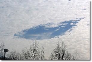
Weather Topic: What are Hole Punch Clouds?
Home - Education - Cloud Types - Hole Punch Clouds
 Next Topic: Mammatus Clouds
A hole punch cloud is an unusual occurrence when a disk-shaped
hole appears in a cirrostratus, cirrocumulus, or altocumulus cloud.
When part of the cloud forms ice crystals, water droplets in the surrounding area
of the cloud evaporate. The effect of this process produces a large elliptical
gap in the cloud. The hole punch cloud formation is rare, but it is not specific
to any geographic area.
Other names which have been used to describe this phenomena include fallstreak hole,
skypunch, and cloud hole.
Next Topic: Mammatus Clouds
Weather Topic: What are Nimbostratus Clouds?
Home - Education - Cloud Types - Nimbostratus Clouds
 Next Topic: Precipitation
A nimbostratus cloud is similar to a stratus cloud in its formless,
smooth appearance. However, a nimbostratus cloud is darker than a stratus cloud,
because it is thicker.
Unlike a stratus cloud, a nimbostratus cloud typically brings with it the threat
of moderate to heavy precipitation. In some cases, the precipitation may evaporate
before reaching the ground, a phenomenon known as virga.
Next Topic: Precipitation
Current conditions powered by WeatherAPI.com


