Weather Alert in California
Cold Weather Advisory issued February 17 at 2:59AM PST until February 18 at 9:00AM PST by NWS San Francisco CA
AREAS AFFECTED: North Bay Interior Mountains; North Bay Interior Valleys; Southern Salinas Valley/Arroyo Seco and Lake San Antonio
DESCRIPTION: * WHAT...Cold conditions with temperatures as low as 34 expected. * WHERE...Southern Salinas Valley/Arroyo Seco and Lake San Antonio, North Bay Interior Mountains, and North Bay Interior Valleys. * WHEN...From midnight tonight to 9 AM PST Wednesday. * IMPACTS...Cold conditions will be hazardous to sensitive populations such as unhoused individuals. Prolonged exposure to the cold conditions will lead to hypothermia for people, pets, and livestock. Cold conditions may damage or kill sensitive crops, plants, and vegetation if appropriate precautions are not taken.
INSTRUCTION: Ensure portable heaters are working properly and are used correctly to avoid sparking a fire indoors. Do not use generators or grills inside as carbon monoxide poisoning can result. Check with your local, city, or county officials for information on available warming centers. Be sure to dress in layers if outdoors. Make sure that pets and livestock have adequate food, unfrozen water, and warmth. Cover or tend to sensitive crops, plants, and vegetation.
Want more detail? Get the Complete 7 Day and Night Detailed Forecast!
Current U.S. National Radar--Current
The Current National Weather Radar is shown below with a UTC Time (subtract 5 hours from UTC to get Eastern Time).

National Weather Forecast--Current
The Current National Weather Forecast and National Weather Map are shown below.

National Weather Forecast for Tomorrow
Tomorrow National Weather Forecast and Tomorrow National Weather Map are show below.

North America Water Vapor (Moisture)
This map shows recent moisture content over North America. Bright and colored areas show high moisture (ie, clouds); brown indicates very little moisture present; black indicates no moisture.

Weather Topic: What is Freezing Rain?
Home - Education - Precipitation - Freezing Rain
 Next Topic: Graupel
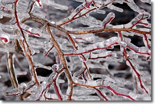
Freezing rain is a condition where precipitation which has fallen in the form of
water droplets reaches temperatures which are below freezing and freezes upon
coming into contact
with surface objects. The result of this precipitation is a glaze of ice which
can be damaging to plants and man-made structures. A severe onset of freezing
rain which results in a very thick glaze of ice is known as an ice storm.
Next Topic: Graupel
Weather Topic: What is Hail?
Home - Education - Precipitation - Hail
 Next Topic: Hole Punch Clouds
Hail is a form of precipitation which is recognized by large solid balls or
clumps of ice. Hail is created by thunderstorm clouds with strong updrafts of wind.
As the hailstones remain in the updraft, ice is deposited onto them until their
weight becomes heavy enough for them to fall to the earth's surface.
Hail storms can cause significant damage to crops, aircrafts, and man-made structures,
despite the fact that the duration is usually less than ten minutes.
Next Topic: Hole Punch Clouds
Current conditions powered by WeatherAPI.com


