Weather Alert in West Virginia
Snow Squall Warning issued March 16 at 10:17PM EDT until March 16 at 10:45PM EDT by NWS Charleston WV
AREAS AFFECTED: Braxton, WV; Clay, WV; Lewis, WV; Nicholas, WV; Randolph, WV; Roane, WV; Upshur, WV; Webster, WV
DESCRIPTION: The National Weather Service in Charleston West Virginia has issued a * Snow Squall Warning for... West central Randolph County in northeastern West Virginia... North central Nicholas County in southeastern West Virginia... Southeastern Lewis County in northern West Virginia... Southern Braxton County in north central West Virginia... Southern Upshur County in northeastern West Virginia... Southeastern Roane County in central West Virginia... Northern Webster County in northeastern West Virginia... Northern Clay County in north central West Virginia... * Until 1045 PM EDT. * At 1017 PM EDT, a dangerous snow squall was located along a line extending from near Rock Cave to near Sutton to near Amma, moving east at 35 mph. HAZARD...Intense bursts of heavy snow. Gusty winds leading to blowing snow and rapidly falling visibility. Wind gusts up to 35 mph. SOURCE...Radar and webcams. IMPACT...Travel will become difficult and potentially dangerous within minutes. This includes the following highways... Interstate 79 between mile markers 24 and 61. Route 19 between mile markers 54 and 68. Locations impacted include... Sutton, Webster Springs, Addison (Webster Springs), Mill Creek, Dailey, Birch River, Holly River State Park, Big Otter, Wallback, Amma, Harrison, Beverly, Huttonsville, Alexander, Eden, Helvetia, Pickens, Cleveland, Waneta, and Boggs.
INSTRUCTION: Slow Down! Rapid changes in visibility and road conditions are expected with this dangerous snow squall. Be alert for sudden whiteout conditions.
Want more detail? Get the Complete 7 Day and Night Detailed Forecast!
Current U.S. National Radar--Current
The Current National Weather Radar is shown below with a UTC Time (subtract 5 hours from UTC to get Eastern Time).

National Weather Forecast--Current
The Current National Weather Forecast and National Weather Map are shown below.

National Weather Forecast for Tomorrow
Tomorrow National Weather Forecast and Tomorrow National Weather Map are show below.

North America Water Vapor (Moisture)
This map shows recent moisture content over North America. Bright and colored areas show high moisture (ie, clouds); brown indicates very little moisture present; black indicates no moisture.

Weather Topic: What are Cirrostratus Clouds?
Home - Education - Cloud Types - Cirrostratus Clouds
 Next Topic: Cirrus Clouds
Cirrostratus clouds are high, thin clouds that form above
20,000 feet and are made mostly of ice crystals. They sometimes look like giant
feathers, horse tails, or curls of hair in the sky.
These clouds are pushed by the jet stream and can move at high speeds reaching
100 mph.
What do they indicate?
They indicate that a precipitation is likely within 24 hours.
Next Topic: Cirrus Clouds
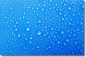
Weather Topic: What is Condensation?
Home - Education - Precipitation - Condensation
 Next Topic: Contrails
Condensation is the process which creates clouds, and therefore
it is a crucial process in the water cycle.
Condensation is the change of matter from a state of gas into a state of liquid,
and it happens because water molecules release heat into the atmosphere and
become organized into a more closely packed structure, what we might see as
water droplets.
Water is always present in the air around us as a vapor, but it's too small for
us to see. When water undergoes the process of condensation it becomes organized
into visible water droplets. You've probably seen condensation happen before on the
surface of a cold drink!
Next Topic: Contrails
Current conditions powered by WeatherAPI.com


