Weather Alert in Colorado
Avalanche Warning issued February 16 at 5:21PM MST by NWS Denver CO
AREAS AFFECTED: West Elk and Sawatch Mountains
DESCRIPTION: AVWBOU THE FOLLOWING MESSAGE IS TRANSMITTED AT THE REQUEST OF THE COLORADO AVALANCHE INFORMATION CENTER. AVALANCHE WARNING IN EFFECT FROM TUESDAY MORNING THROUGH FRIDAY *WHAT Heavy snow and strong winds will result in HIGH (4 of 5) avalanche danger *WHERE The West Elk Mountains including the Ruby and Ragged Ranges *WHEN Expect very dangerous avalanche conditions to begin Tuesday and last through Friday *IMPACTS Large and dangerous avalanches will be easy to trigger. Large avalanches will run naturally. *PRECAUTION/PREPAREDNESS ACTIONS Travel in backcountry avalanche terrain is not recommended from Tuesday through Friday. Avoid travel on and under slopes with a slope angle steeper than about 30 degrees. You can find more detailed information at colorado.gov/avalanche
INSTRUCTION: N/A
Want more detail? Get the Complete 7 Day and Night Detailed Forecast!
Current U.S. National Radar--Current
The Current National Weather Radar is shown below with a UTC Time (subtract 5 hours from UTC to get Eastern Time).

National Weather Forecast--Current
The Current National Weather Forecast and National Weather Map are shown below.

National Weather Forecast for Tomorrow
Tomorrow National Weather Forecast and Tomorrow National Weather Map are show below.

North America Water Vapor (Moisture)
This map shows recent moisture content over North America. Bright and colored areas show high moisture (ie, clouds); brown indicates very little moisture present; black indicates no moisture.

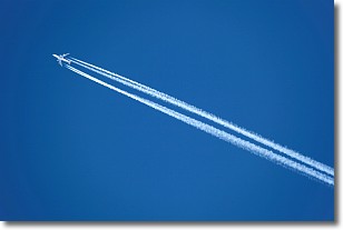
Weather Topic: What are Contrails?
Home - Education - Cloud Types - Contrails
 Next Topic: Cumulonimbus Clouds
A contrail is an artificial cloud, created by the passing of an
aircraft.
Contrails form because water vapor in the exhaust of aircraft engines is suspended
in the air under certain temperatures and humidity conditions. These contrails
are called exhaust contrails.
Another type of contrail can form due to a temporary reduction in air pressure
moving over the plane's surface, causing condensation.
These are called aerodynamic contrails.
When you can see your breath on a cold day, it is also because of condensation.
The reason contrails last longer than the condensation from your breath is
because the water in contrails freezes into ice particles.
Next Topic: Cumulonimbus Clouds
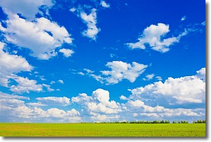
Weather Topic: What are Cumulus Clouds?
Home - Education - Cloud Types - Cumulus Clouds
 Next Topic: Drizzle
Cumulus clouds are fluffy and textured with rounded tops, and
may have flat bottoms. The border of a cumulus cloud
is clearly defined, and can have the appearance of cotton or cauliflower.
Cumulus clouds form at low altitudes (rarely above 2 km) but can grow very tall,
becoming cumulus congestus and possibly the even taller cumulonimbus clouds.
When cumulus clouds become taller, they have a greater chance of producing precipitation.
Next Topic: Drizzle
Current conditions powered by WeatherAPI.com


