Weather Alert in New Mexico
Flash Flood Warning issued August 23 at 1:20PM MDT until August 23 at 4:15PM MDT by NWS Albuquerque NM
AREAS AFFECTED: San Miguel, NM
DESCRIPTION: FFWABQ The National Weather Service in Albuquerque has issued a * Flash Flood Warning for... The Hermits Peak and Calf Canyon Burn Scar in... Northwestern San Miguel County in northeastern New Mexico... * Until 415 PM MDT. * At 120 PM MDT, Doppler radar indicated thunderstorms producing heavy rain over the Hermits Peak and Calf Canyon Burn Scar. Between 0.5 and 1.25 inches of rain have fallen. Additional rainfall amounts of 0.5 to 1 inch are possible in the warned area. Flash flooding is ongoing or expected to begin shortly. Excessive rainfall over the burn scar will impact Manuelitas Creek, the Sapello River, Tecolote Creek and the Gallinas River. The debris flow can consist of rock, mud, vegetation and other loose materials. HAZARD...Life threatening flash flooding. Thunderstorms producing flash flooding in and around the Hermits Peak and Calf Canyon Burn Scar. SOURCE...Radar indicated. IMPACT...Life threatening flash flooding of areas in and around the Hermits Peak and Calf Canyon Burn Scar. * Some locations that will experience flash flooding include... El Porvenir, Montezuma, Sapello, Tierra Monte, Gallinas, Mineral Hill, Rociada, Manuelitas and San Geronimo. The heaviest rain has fallen in the Beaver Creek drainage area.
INSTRUCTION: This is a life threatening situation. Heavy rainfall will cause extensive and severe flash flooding of creeks, streams and ditches in the Hermits Peak and Calf Canyon Burn Scar. Severe debris flows can also be anticipated across roads. Roads and driveways may be washed away in places. If you encounter flood waters, climb to safety.
Want more detail? Get the Complete 7 Day and Night Detailed Forecast!
Current U.S. National Radar--Current
The Current National Weather Radar is shown below with a UTC Time (subtract 5 hours from UTC to get Eastern Time).

National Weather Forecast--Current
The Current National Weather Forecast and National Weather Map are shown below.

National Weather Forecast for Tomorrow
Tomorrow National Weather Forecast and Tomorrow National Weather Map are show below.

North America Water Vapor (Moisture)
This map shows recent moisture content over North America. Bright and colored areas show high moisture (ie, clouds); brown indicates very little moisture present; black indicates no moisture.

Weather Topic: What is Graupel?
Home - Education - Precipitation - Graupel
 Next Topic: Hail
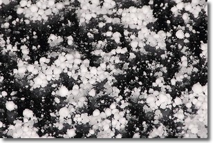
Graupel is a form of precipitation that is created by atmospheric conditions
which cause supercooled water droplets to contact snow crystals and freeze to
their surface.
Sometimes known as soft hail or snow pellets, graupel is delicate and easily
destroyed by touch. Whereas hail usually falls during severe weather, graupel
doesn't require such conditions to form, and can form in mild precipitation
similar to situations which produce snowfall.
Next Topic: Hail
Weather Topic: What are Hole Punch Clouds?
Home - Education - Cloud Types - Hole Punch Clouds
 Next Topic: Mammatus Clouds
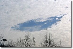
A hole punch cloud is an unusual occurrence when a disk-shaped
hole appears in a cirrostratus, cirrocumulus, or altocumulus cloud.
When part of the cloud forms ice crystals, water droplets in the surrounding area
of the cloud evaporate. The effect of this process produces a large elliptical
gap in the cloud. The hole punch cloud formation is rare, but it is not specific
to any geographic area.
Other names which have been used to describe this phenomena include fallstreak hole,
skypunch, and cloud hole.
Next Topic: Mammatus Clouds
Current conditions powered by WeatherAPI.com


