Weather Alert in Idaho
Avalanche Warning issued February 17 at 6:39AM MST by NWS Pocatello ID
AREAS AFFECTED: Sawtooth/Stanley Basin; Sun Valley Region; Big Lost Highlands/Copper Basin
DESCRIPTION: AVWPIH * WHAT...Avalanche warning. The avalanche danger is HIGH. The combination of heavy snowfall and wind is overloading a weak snowpack. * WHERE...The Pioneer, Boulder, Smoky and southern White Cloud Mountains, including the mountains near Triumph, Trail Creek Summit, Baker Creek, Galena Summit, and Smiley Creek. * WHEN...Through 4 AM MST Wednesday. * IMPACTS...Natural and human triggered avalanches large enough to bury people, snap trees, and destroy structures are near certain to occur.
INSTRUCTION: Very dangerous avalanche conditions exist. Travel in avalanche terrain is not recommended. Stay off and out from below steep slopes, slopes steeper than about 30 degrees. Avalanches may be triggered remotely, from flat terrain above, below, and to the sides of steep slopes. Consult www.sawtoothavalanche.com or www.avalanche.org for more detailed information. Similar avalanche danger may exist at locations outside the coverage area of this or any avalanche center.
Want more detail? Get the Complete 7 Day and Night Detailed Forecast!
Current U.S. National Radar--Current
The Current National Weather Radar is shown below with a UTC Time (subtract 5 hours from UTC to get Eastern Time).

National Weather Forecast--Current
The Current National Weather Forecast and National Weather Map are shown below.

National Weather Forecast for Tomorrow
Tomorrow National Weather Forecast and Tomorrow National Weather Map are show below.

North America Water Vapor (Moisture)
This map shows recent moisture content over North America. Bright and colored areas show high moisture (ie, clouds); brown indicates very little moisture present; black indicates no moisture.

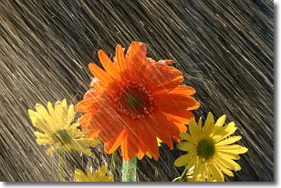
Weather Topic: What is Rain?
Home - Education - Precipitation - Rain
 Next Topic: Shelf Clouds
Precipitation in the form of water droplets is called rain.
Rain generally has a tendency to fall with less intensity over a greater period
of time, and when rainfall is more severe it is usually less sustained.
Rain is the most common form of precipitation and happens with greater frequency
depending on the season and regional influences. Cities have been shown to have
an observable effect on rainfall, due to an effect called the urban heat island.
Compared to upwind, monthly rainfall between twenty and forty miles downwind of
cities is 30% greater.
Next Topic: Shelf Clouds
Weather Topic: What is Sleet?
Home - Education - Precipitation - Sleet
 Next Topic: Snow
Sleet is a form of precipitation in which small ice pellets are the primary
components. These ice pellets are smaller and more translucent than hailstones,
and harder than graupel. Sleet is caused by specific atmospheric conditions and
therefore typically doesn't last for extended periods of time.
The condition which leads to sleet formation requires a warmer body of air to be
wedged in between two sub-freezing bodies of air. When snow falls through a warmer
layer of air it melts, and as it falls through the next sub-freezing body of air
it freezes again, forming ice pellets known as sleet. In some cases, water
droplets don't have time to freeze before reaching the surface and the result is
freezing rain.
Next Topic: Snow
Current conditions powered by WeatherAPI.com


