Weather Alert in New Mexico
High Wind Warning issued February 17 at 11:38AM MST until February 17 at 8:00PM MST by NWS Albuquerque NM
AREAS AFFECTED: Glorieta Mesa Including Glorieta Pass; Sandia/Manzano Mountains Including Edgewood; Estancia Valley; Johnson and Bartlett Mesas Including Raton Pass; Far Northeast Highlands; Union County; Harding County; Eastern San Miguel County; Quay County; Curry County; Roosevelt County; De Baca County; Chaves County Plains
DESCRIPTION: * WHAT...Southwest to west winds 35 to 45 mph with gusts up to 70 mph expected. * WHERE...The eastern plains, far Northeast Highlands, Sandia and Manzano Mountains, and the south central mountains. * WHEN...Until 8 PM MST this evening. * IMPACTS...Damaging winds could blow down trees and power lines. Power outages are possible. Travel will be difficult, especially for high profile vehicles. * ADDITIONAL DETAILS...Visibility may drop below one mile at times in blowing dust on the eastern plains, especially around Roswell.
INSTRUCTION: Take action to secure trash cans, lawn furniture, and other loose or lightweight outdoor objects. Dangerous driving conditions can be expected, especially for motorists in high profile vehicles and during periods of dense blowing dust.
Want more detail? Get the Complete 7 Day and Night Detailed Forecast!
Current U.S. National Radar--Current
The Current National Weather Radar is shown below with a UTC Time (subtract 5 hours from UTC to get Eastern Time).

National Weather Forecast--Current
The Current National Weather Forecast and National Weather Map are shown below.

National Weather Forecast for Tomorrow
Tomorrow National Weather Forecast and Tomorrow National Weather Map are show below.

North America Water Vapor (Moisture)
This map shows recent moisture content over North America. Bright and colored areas show high moisture (ie, clouds); brown indicates very little moisture present; black indicates no moisture.

Weather Topic: What is Sleet?
Home - Education - Precipitation - Sleet
 Next Topic: Snow
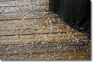
Sleet is a form of precipitation in which small ice pellets are the primary
components. These ice pellets are smaller and more translucent than hailstones,
and harder than graupel. Sleet is caused by specific atmospheric conditions and
therefore typically doesn't last for extended periods of time.
The condition which leads to sleet formation requires a warmer body of air to be
wedged in between two sub-freezing bodies of air. When snow falls through a warmer
layer of air it melts, and as it falls through the next sub-freezing body of air
it freezes again, forming ice pellets known as sleet. In some cases, water
droplets don't have time to freeze before reaching the surface and the result is
freezing rain.
Next Topic: Snow
Weather Topic: What are Stratocumulus Clouds?
Home - Education - Cloud Types - Stratocumulus Clouds
 Next Topic: Stratus Clouds
Stratocumulus clouds are similar to altocumulus clouds in their
fluffy appearance, but have a slightly darker shade due to their additional mass.
A good way to distinguish the two cloud types is to hold your hand out and measure
the size of an individual cloud; if it is the size of your thumb it is generally
an altocumulus cloud, if it is the size of your hand it is generally a
stratocumulus cloud.
It is uncommon for stratocumulus clouds to produce precipitation, but if they do
it is usually a light rain or snow.
Next Topic: Stratus Clouds
Current conditions powered by WeatherAPI.com


