Weather Alert in Massachusetts
Severe Thunderstorm Warning issued September 6 at 3:09PM EDT until September 6 at 3:45PM EDT by NWS Boston/Norton MA
AREAS AFFECTED: Franklin, MA; Hampden, MA; Hampshire, MA; Worcester, MA
DESCRIPTION: At 307 PM EDT, a severe thunderstorm was located over Ludlow, or 8 miles east of Chicopee, moving east at 45 mph. HAZARD...60 mph wind gusts and quarter size hail. SOURCE...Numerous reports of wind damage. IMPACT...Hail damage to vehicles is expected. Expect wind damage to trees and power lines. Locations impacted include... Worcester, Springfield, Chicopee, Holyoke, Amherst, Northampton, Agawam, West Springfield, Ludlow, South Hadley, Holden, Webster, Southbridge, Auburn, Easthampton, Longmeadow, East Longmeadow, Belchertown, Wilbraham, and Oxford.
INSTRUCTION: This is a DANGEROUS SITUATION. This storm is producing widespread wind damage and Westfield has just reported a wind gust of 64 mph when the thunderstorm crossed the region. SEEK SHELTER NOW inside a sturdy structure and stay away from windows. Continuous cloud to ground lightning is occurring with this storm. Move indoors immediately. Lightning is one of nature's leading killers. Remember, if you can hear thunder, you are close enough to be struck by lightning.
Want more detail? Get the Complete 7 Day and Night Detailed Forecast!
Current U.S. National Radar--Current
The Current National Weather Radar is shown below with a UTC Time (subtract 5 hours from UTC to get Eastern Time).

National Weather Forecast--Current
The Current National Weather Forecast and National Weather Map are shown below.

National Weather Forecast for Tomorrow
Tomorrow National Weather Forecast and Tomorrow National Weather Map are show below.

North America Water Vapor (Moisture)
This map shows recent moisture content over North America. Bright and colored areas show high moisture (ie, clouds); brown indicates very little moisture present; black indicates no moisture.

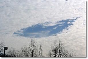
Weather Topic: What are Hole Punch Clouds?
Home - Education - Cloud Types - Hole Punch Clouds
 Next Topic: Mammatus Clouds
A hole punch cloud is an unusual occurrence when a disk-shaped
hole appears in a cirrostratus, cirrocumulus, or altocumulus cloud.
When part of the cloud forms ice crystals, water droplets in the surrounding area
of the cloud evaporate. The effect of this process produces a large elliptical
gap in the cloud. The hole punch cloud formation is rare, but it is not specific
to any geographic area.
Other names which have been used to describe this phenomena include fallstreak hole,
skypunch, and cloud hole.
Next Topic: Mammatus Clouds
Weather Topic: What are Nimbostratus Clouds?
Home - Education - Cloud Types - Nimbostratus Clouds
 Next Topic: Precipitation
A nimbostratus cloud is similar to a stratus cloud in its formless,
smooth appearance. However, a nimbostratus cloud is darker than a stratus cloud,
because it is thicker.
Unlike a stratus cloud, a nimbostratus cloud typically brings with it the threat
of moderate to heavy precipitation. In some cases, the precipitation may evaporate
before reaching the ground, a phenomenon known as virga.
Next Topic: Precipitation
Current conditions powered by WeatherAPI.com


