Weather Alert in California
Flood Watch issued February 17 at 2:42AM PST until February 18 at 3:00AM PST by NWS Los Angeles/Oxnard CA
AREAS AFFECTED: Cuyama Valley; San Luis Obispo County Beaches; San Luis Obispo County Inland Central Coast; Santa Lucia Mountains; Southern Salinas Valley; San Luis Obispo County Interior Valleys; San Luis Obispo County Mountains; Santa Barbara County Central Coast Beaches; Santa Barbara County Inland Central Coast; Santa Ynez Valley; Santa Barbara County Southwestern Coast; Santa Barbara County Southeastern Coast; Santa Ynez Mountains Western Range; Santa Ynez Mountains Eastern Range; Santa Barbara County Interior Mountains
DESCRIPTION: * WHAT...Flooding caused by excessive rainfall is possible. Rock and mud slides are possible near steep terrain and along canyon roads. Debris flows are possible on recent burn scars. * WHERE...A portion of southwest California, including the following counties, San Luis Obispo and Santa Barbara Counties. * WHEN...From this afternoon through late tonight. * IMPACTS...Flash flooding is possible. Excessive runoff may result in flooding of low-lying and flood-prone locations, including creeks and streams. Flooding may occur in poor drainage and urban areas. Low-water crossings may be flooded. Extensive street flooding is possible. * ADDITIONAL DETAILS... - A line of heavy showers and thunderstorms will sweep across the region this afternoon into evening, bringing the risk for flash flooding, rock and mud slides, and burn-scar debris flows across the Flood Watch area. After the passage of the line, scattered heavy showers and thunderstorms will continue into late tonight, prolonging the flooding risk in isolated locations. Flooding and burn-scar debris flows are not expected for areas above the snow level, of approximately 4500 feet elevation, where snow will fall instead of rain. - http://www.weather.gov/safety/flood
INSTRUCTION: You should monitor later forecasts and be alert for possible Flood Warnings. Those living in areas prone to flooding and near recent burn scars should be prepared to take action should flooding develop. Travel through passes and canyons could become dangerous, and be alert for rock slides and mud slides. Follow the direction of Emergency Management and Law Enforcement officials.
Want more detail? Get the Complete 7 Day and Night Detailed Forecast!
Current U.S. National Radar--Current
The Current National Weather Radar is shown below with a UTC Time (subtract 5 hours from UTC to get Eastern Time).

National Weather Forecast--Current
The Current National Weather Forecast and National Weather Map are shown below.

National Weather Forecast for Tomorrow
Tomorrow National Weather Forecast and Tomorrow National Weather Map are show below.

North America Water Vapor (Moisture)
This map shows recent moisture content over North America. Bright and colored areas show high moisture (ie, clouds); brown indicates very little moisture present; black indicates no moisture.

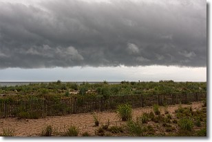
Weather Topic: What are Shelf Clouds?
Home - Education - Cloud Types - Shelf Clouds
 Next Topic: Sleet
A shelf cloud is similar to a wall cloud, but forms at the front
of a storm cloud, instead of at the rear, where wall clouds form.
A shelf cloud is caused by a series of events set into motion by the advancing
storm; first, cool air settles along the ground where precipitation has just fallen.
As the cool air is brought in, the warmer air is displaced, and rises above it,
because it is less dense. When the warmer air reaches the bottom of the storm cloud,
it begins to cool again, and the resulting condensation is a visible shelf cloud.
Next Topic: Sleet
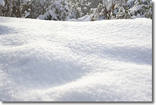
Weather Topic: What is Snow?
Home - Education - Precipitation - Snow
 Next Topic: Stratocumulus Clouds
Snow is precipitation taking the form of ice crystals. Each ice crystal, or snowflake,
has unique characteristics, but all of them grow in a hexagonal structure.
Snowfall can last for sustained periods of time and result in significant buildup
of snow on the ground.
On the earth's surface, snow starts out light and powdery, but as it begins to melt
it tends to become more granular, producing small bits of ice which have the consistency of
sand. After several cycles of melting and freezing, snow can become very dense
and ice-like, commonly known as snow pack.
Next Topic: Stratocumulus Clouds
Current conditions powered by WeatherAPI.com


