Weather Alert in Indiana
Winter Weather Advisory issued February 21 at 1:36PM EST until February 23 at 1:00PM EST by NWS Northern Indiana
AREAS AFFECTED: Northern La Porte; Eastern St. Joseph; Southern La Porte; Western St. Joseph; Cass; Northern Berrien; Southern Berrien
DESCRIPTION: * WHAT...Lake effect snow expected. Total snow accumulations between 3 and 5 inches with locally higher amounts possible. * WHERE...Portions of northern Indiana and southwest Michigan. * WHEN...From 1 AM EST /midnight CST/ Sunday to 1 PM EST /noon CST/ Monday. * IMPACTS...Plan on slippery road conditions. The hazardous conditions could impact the Monday morning commute. * ADDITIONAL DETAILS...A system will bring light snow with some lake enhancement tonight into Sunday. The greatest snowfall rates and a potential of more organized lake effect snow banding is Sunday evening into early Monday morning. Some blowing and drifting snow is possible.
INSTRUCTION: Slow down and use caution while traveling. The latest road conditions for the state you are calling from can be obtained by calling 5 1 1.
Want more detail? Get the Complete 7 Day and Night Detailed Forecast!
Current U.S. National Radar--Current
The Current National Weather Radar is shown below with a UTC Time (subtract 5 hours from UTC to get Eastern Time).

National Weather Forecast--Current
The Current National Weather Forecast and National Weather Map are shown below.

National Weather Forecast for Tomorrow
Tomorrow National Weather Forecast and Tomorrow National Weather Map are show below.

North America Water Vapor (Moisture)
This map shows recent moisture content over North America. Bright and colored areas show high moisture (ie, clouds); brown indicates very little moisture present; black indicates no moisture.

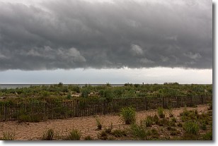
Weather Topic: What are Shelf Clouds?
Home - Education - Cloud Types - Shelf Clouds
 Next Topic: Sleet
A shelf cloud is similar to a wall cloud, but forms at the front
of a storm cloud, instead of at the rear, where wall clouds form.
A shelf cloud is caused by a series of events set into motion by the advancing
storm; first, cool air settles along the ground where precipitation has just fallen.
As the cool air is brought in, the warmer air is displaced, and rises above it,
because it is less dense. When the warmer air reaches the bottom of the storm cloud,
it begins to cool again, and the resulting condensation is a visible shelf cloud.
Next Topic: Sleet
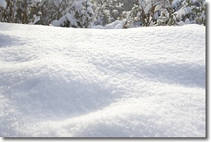
Weather Topic: What is Snow?
Home - Education - Precipitation - Snow
 Next Topic: Stratocumulus Clouds
Snow is precipitation taking the form of ice crystals. Each ice crystal, or snowflake,
has unique characteristics, but all of them grow in a hexagonal structure.
Snowfall can last for sustained periods of time and result in significant buildup
of snow on the ground.
On the earth's surface, snow starts out light and powdery, but as it begins to melt
it tends to become more granular, producing small bits of ice which have the consistency of
sand. After several cycles of melting and freezing, snow can become very dense
and ice-like, commonly known as snow pack.
Next Topic: Stratocumulus Clouds
Current conditions powered by WeatherAPI.com


