Weather Alert in California
Winter Storm Watch issued February 13 at 11:29AM PST until February 18 at 10:00PM PST by NWS Sacramento CA
AREAS AFFECTED: Shasta Lake Area / Northern Shasta County; Burney Basin / Eastern Shasta County; Mountains Southwestern Shasta County to Western Colusa County; Northeast Foothills/Sacramento Valley; Motherlode; Western Plumas County/Lassen Park; West Slope Northern Sierra Nevada
DESCRIPTION: * WHAT...Heavy snow possible. Accumulation amounts are uncertain at this time, but may range from around a foot at 3000 to 4000 feet and 4 to 8 feet at higher elevations. Winds could gust as high as 55 mph. * WHERE...West Slope Northern Sierra Nevada and Western Plumas County/Lassen Park including Interstate 80 and Highway 50, northern Shasta County including portions of Interstate 5, the Coastal Range, and foothill regions of the Sierra Nevada. * WHEN...From Sunday evening through Wednesday evening. * IMPACTS...Dangerous to near impossible travel conditions with chain controls and road closures possible. Low visibility due to a combination of wind and heavy snow. * ADDITIONAL DETAILS...Snow levels will be around 4500-5000 feet Sunday night through Tuesday. Levels drop to 3000 to 4000 feet late Tuesday into Wednesday. Potential to see snow levels as low as 2000 feet for areas along the Coastal Range, around Shasta County, and in the southern Cascades.
INSTRUCTION: Check the latest road conditions from Caltrans online at quickmap.dot.ca.gov or dial 5 1 1.
Want more detail? Get the Complete 7 Day and Night Detailed Forecast!
Current U.S. National Radar--Current
The Current National Weather Radar is shown below with a UTC Time (subtract 5 hours from UTC to get Eastern Time).

National Weather Forecast--Current
The Current National Weather Forecast and National Weather Map are shown below.

National Weather Forecast for Tomorrow
Tomorrow National Weather Forecast and Tomorrow National Weather Map are show below.

North America Water Vapor (Moisture)
This map shows recent moisture content over North America. Bright and colored areas show high moisture (ie, clouds); brown indicates very little moisture present; black indicates no moisture.

Weather Topic: What are Cirrostratus Clouds?
Home - Education - Cloud Types - Cirrostratus Clouds
 Next Topic: Cirrus Clouds
Cirrostratus clouds are high, thin clouds that form above
20,000 feet and are made mostly of ice crystals. They sometimes look like giant
feathers, horse tails, or curls of hair in the sky.
These clouds are pushed by the jet stream and can move at high speeds reaching
100 mph.
What do they indicate?
They indicate that a precipitation is likely within 24 hours.
Next Topic: Cirrus Clouds
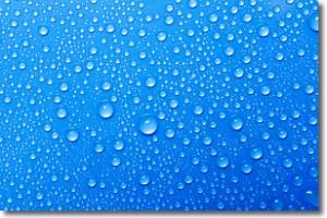
Weather Topic: What is Condensation?
Home - Education - Precipitation - Condensation
 Next Topic: Contrails
Condensation is the process which creates clouds, and therefore
it is a crucial process in the water cycle.
Condensation is the change of matter from a state of gas into a state of liquid,
and it happens because water molecules release heat into the atmosphere and
become organized into a more closely packed structure, what we might see as
water droplets.
Water is always present in the air around us as a vapor, but it's too small for
us to see. When water undergoes the process of condensation it becomes organized
into visible water droplets. You've probably seen condensation happen before on the
surface of a cold drink!
Next Topic: Contrails
Current conditions powered by WeatherAPI.com


