Weather Alert in California
Winter Storm Watch issued February 13 at 11:29AM PST until February 18 at 10:00PM PST by NWS Sacramento CA
AREAS AFFECTED: Shasta Lake Area / Northern Shasta County; Burney Basin / Eastern Shasta County; Mountains Southwestern Shasta County to Western Colusa County; Northeast Foothills/Sacramento Valley; Motherlode; Western Plumas County/Lassen Park; West Slope Northern Sierra Nevada
DESCRIPTION: * WHAT...Heavy snow possible. Accumulation amounts are uncertain at this time, but may range from around a foot at 3000 to 4000 feet and 4 to 8 feet at higher elevations. Winds could gust as high as 55 mph. * WHERE...West Slope Northern Sierra Nevada and Western Plumas County/Lassen Park including Interstate 80 and Highway 50, northern Shasta County including portions of Interstate 5, the Coastal Range, and foothill regions of the Sierra Nevada. * WHEN...From Sunday evening through Wednesday evening. * IMPACTS...Dangerous to near impossible travel conditions with chain controls and road closures possible. Low visibility due to a combination of wind and heavy snow. * ADDITIONAL DETAILS...Snow levels will be around 4500-5000 feet Sunday night through Tuesday. Levels drop to 3000 to 4000 feet late Tuesday into Wednesday. Potential to see snow levels as low as 2000 feet for areas along the Coastal Range, around Shasta County, and in the southern Cascades.
INSTRUCTION: Check the latest road conditions from Caltrans online at quickmap.dot.ca.gov or dial 5 1 1.
Want more detail? Get the Complete 7 Day and Night Detailed Forecast!
Current U.S. National Radar--Current
The Current National Weather Radar is shown below with a UTC Time (subtract 5 hours from UTC to get Eastern Time).

National Weather Forecast--Current
The Current National Weather Forecast and National Weather Map are shown below.

National Weather Forecast for Tomorrow
Tomorrow National Weather Forecast and Tomorrow National Weather Map are show below.

North America Water Vapor (Moisture)
This map shows recent moisture content over North America. Bright and colored areas show high moisture (ie, clouds); brown indicates very little moisture present; black indicates no moisture.

Weather Topic: What are Cirrus Clouds?
Home - Education - Cloud Types - Cirrus Clouds
 Next Topic: Condensation
Cirrus clouds are high-level clouds that occur above 20,000 feet
and are composed mainly of ice crystals.
They are thin and wispy in appearance.
What do they indicate?
They are often the first sign of an approaching storm.
Next Topic: Condensation
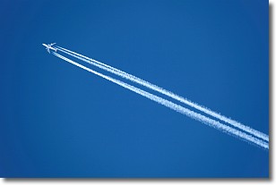
Weather Topic: What are Contrails?
Home - Education - Cloud Types - Contrails
 Next Topic: Cumulonimbus Clouds
A contrail is an artificial cloud, created by the passing of an
aircraft.
Contrails form because water vapor in the exhaust of aircraft engines is suspended
in the air under certain temperatures and humidity conditions. These contrails
are called exhaust contrails.
Another type of contrail can form due to a temporary reduction in air pressure
moving over the plane's surface, causing condensation.
These are called aerodynamic contrails.
When you can see your breath on a cold day, it is also because of condensation.
The reason contrails last longer than the condensation from your breath is
because the water in contrails freezes into ice particles.
Next Topic: Cumulonimbus Clouds
Current conditions powered by WeatherAPI.com


