Weather Alert in Washington
Special Weather Statement issued March 19 at 12:11PM PDT by NWS Seattle WA
AREAS AFFECTED: San Juan County; Cascades of Whatcom and Skagit Counties; Cascades of Snohomish and Northern King Counties; Cascades of Southern King County; Cascades of Pierce and Lewis Counties; Foothills and Valleys of the North Cascades; Foothills and Valleys of Snohomish and Northern King Counties; Foothills and Valleys of Central King County; Foothills and Valleys of Pierce and Southern King Counties; Lowlands of Western Whatcom County; Lowlands of Western Skagit and Northwestern Snohomish Counties; Downtown Everett / Marysville Area; Shoreline / Lynnwood / South Everett Area; Eastside; City of Seattle; Lowlands of Pierce and Southern King Counties; Olympia and Southern Puget Sound; Middle Chehalis River Valley; Willapa and Black Hills; Southern Hood Canal; Western Strait of Juan de Fuca; Lake Crescent Area Including US 101; Olympics; Foothills of the Western and Southern Olympic Peninsula; Northern Washington Coast; Grays Harbor County Coast; Lower Chehalis River Valley
DESCRIPTION: Rainfall of 2 to 7 inches over the past 3 days has increased soil moisture to high levels across western Washington. Heavy rainfall of 0.75 up to 4 inches is expected over the next 30 hours. This amount of rain will put extra pressure on soil instability, leading to an increased threat of landslides and debris flows, especially from recent burned areas. Over the last couple days at least one landslide has been reported in King County. More landslides are possible. Areas most susceptible to landslides debris flows under these conditions are steep coastal bluffs, other steep hillsides or road cuts, and recent burned areas. A diminishing threat of landslides and debris flows will continue for several days after the rain ends. For more information about current conditions, visit www.weather.gov/seattle, select Hydrology, and then scroll down for the links to the landslide information pages. For more information on landslides, visit the website for the Washington State Department of Natural Resources landslide geologic hazards at: http://bit.ly/2mtA3wn
INSTRUCTION: N/A
Want more detail? Get the Complete 7 Day and Night Detailed Forecast!
Current U.S. National Radar--Current
The Current National Weather Radar is shown below with a UTC Time (subtract 5 hours from UTC to get Eastern Time).

National Weather Forecast--Current
The Current National Weather Forecast and National Weather Map are shown below.

National Weather Forecast for Tomorrow
Tomorrow National Weather Forecast and Tomorrow National Weather Map are show below.

North America Water Vapor (Moisture)
This map shows recent moisture content over North America. Bright and colored areas show high moisture (ie, clouds); brown indicates very little moisture present; black indicates no moisture.

Weather Topic: What is Precipitation?
Home - Education - Precipitation - Precipitation
 Next Topic: Rain
Precipitation can refer to many different forms of water that
may fall from clouds. Precipitation occurs after a cloud has become saturated to
the point where its water particles are more dense than the air below the cloud.
In most cases, precipitation will reach the ground, but it is not uncommon for
precipitation to evaporate before it reaches the earth's surface.
When precipitation evaporates before it contacts the ground it is called Virga.
Graupel, hail, sleet, rain, drizzle, and snow are forms of precipitation, but fog
and mist are not considered precipitation because the water vapor which
constitutes them isn't dense enough to fall to the ground.
Next Topic: Rain
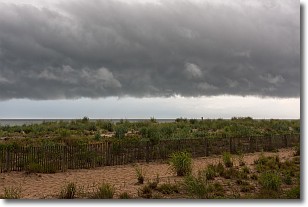
Weather Topic: What are Shelf Clouds?
Home - Education - Cloud Types - Shelf Clouds
 Next Topic: Sleet
A shelf cloud is similar to a wall cloud, but forms at the front
of a storm cloud, instead of at the rear, where wall clouds form.
A shelf cloud is caused by a series of events set into motion by the advancing
storm; first, cool air settles along the ground where precipitation has just fallen.
As the cool air is brought in, the warmer air is displaced, and rises above it,
because it is less dense. When the warmer air reaches the bottom of the storm cloud,
it begins to cool again, and the resulting condensation is a visible shelf cloud.
Next Topic: Sleet
Current conditions powered by WeatherAPI.com


