Weather Alert in California
Flood Watch issued August 26 at 1:53AM PDT until August 26 at 9:00PM PDT by NWS Las Vegas NV
AREAS AFFECTED: Eastern Sierra Slopes of Inyo County; Owens Valley; White Mountains of Inyo County; Death Valley National Park; Esmeralda and Central Nye County
DESCRIPTION: * WHAT...Flash flooding caused by excessive rainfall is possible. * WHERE...Portions of southeastern California, including the following areas, Death Valley National Park, Eastern Sierra Slopes, Owens Valley and White Mountains of Inyo County as well as south-central Nevada, including the following areas, Esmeralda and Central Nye County. * WHEN...From 9 AM PDT this morning through 9 PM PDT this evening. * IMPACTS...Excessive runoff may result in flooding of rivers, creeks, streams, and other low-lying and flood-prone locations. Flooding may occur in poor drainage and urban areas. Low-water crossings may be flooded. * ADDITIONAL DETAILS... - Scattered showers and isolated thunderstorms today will result in moderate-to-heavy rainfall, resulting in instances of flash flooding. - http://www.weather.gov/safety/flood
INSTRUCTION: You should monitor later forecasts and be prepared to take action should Flash Flood Warnings be issued.
Want more detail? Get the Complete 7 Day and Night Detailed Forecast!
Current U.S. National Radar--Current
The Current National Weather Radar is shown below with a UTC Time (subtract 5 hours from UTC to get Eastern Time).

National Weather Forecast--Current
The Current National Weather Forecast and National Weather Map are shown below.

National Weather Forecast for Tomorrow
Tomorrow National Weather Forecast and Tomorrow National Weather Map are show below.

North America Water Vapor (Moisture)
This map shows recent moisture content over North America. Bright and colored areas show high moisture (ie, clouds); brown indicates very little moisture present; black indicates no moisture.

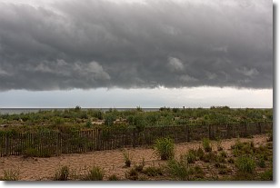
Weather Topic: What are Shelf Clouds?
Home - Education - Cloud Types - Shelf Clouds
 Next Topic: Sleet
A shelf cloud is similar to a wall cloud, but forms at the front
of a storm cloud, instead of at the rear, where wall clouds form.
A shelf cloud is caused by a series of events set into motion by the advancing
storm; first, cool air settles along the ground where precipitation has just fallen.
As the cool air is brought in, the warmer air is displaced, and rises above it,
because it is less dense. When the warmer air reaches the bottom of the storm cloud,
it begins to cool again, and the resulting condensation is a visible shelf cloud.
Next Topic: Sleet
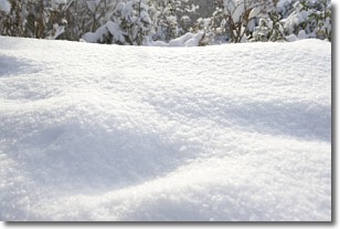
Weather Topic: What is Snow?
Home - Education - Precipitation - Snow
 Next Topic: Stratocumulus Clouds
Snow is precipitation taking the form of ice crystals. Each ice crystal, or snowflake,
has unique characteristics, but all of them grow in a hexagonal structure.
Snowfall can last for sustained periods of time and result in significant buildup
of snow on the ground.
On the earth's surface, snow starts out light and powdery, but as it begins to melt
it tends to become more granular, producing small bits of ice which have the consistency of
sand. After several cycles of melting and freezing, snow can become very dense
and ice-like, commonly known as snow pack.
Next Topic: Stratocumulus Clouds
Current conditions powered by WeatherAPI.com


