Weather Alert in Pennsylvania
Flood Advisory issued February 21 at 6:55AM EST until February 22 at 7:00AM EST by NWS Pittsburgh PA
AREAS AFFECTED: Allegheny, PA
DESCRIPTION: ...The Flood Advisory continues for the following rivers in Pennsylvania... Ohio River At Pittsburgh affecting Allegheny County. .Rain and snow melt will continue to result in elevated levels of the Ohio River at Pittsburgh through early Sunday. * WHAT...Flooding caused by rain and snowmelt continues. * WHERE...Ohio River at Pittsburgh. * WHEN...Until Sunday morning. * IMPACTS...At 18.0 feet, Water begins to flow onto the Monongahela Parking Wharf. At 19.0 feet, Water begins to flow onto the North Shore Riverwalk between the stadiums. At 19.5 feet, The Monongahela Parking Wharf is completely flooded. * ADDITIONAL DETAILS... - At 6:45 AM EST Saturday the stage was 18.9 feet. - Bankfull stage is 18.0 feet. - Forecast...The river is expected to rise again to a crest of 18.9 feet this afternoon, before beginning to fall tonight. - Action stage is 18.0 feet. - Flood stage is 22.0 feet. - http://www.weather.gov/safety/flood
INSTRUCTION: Caution is urged when walking near riverbanks. Additional information is available at weather.gov/pbz. The next statement will be issued this evening at 700 PM EST.
Want more detail? Get the Complete 7 Day and Night Detailed Forecast!
Current U.S. National Radar--Current
The Current National Weather Radar is shown below with a UTC Time (subtract 5 hours from UTC to get Eastern Time).

National Weather Forecast--Current
The Current National Weather Forecast and National Weather Map are shown below.

National Weather Forecast for Tomorrow
Tomorrow National Weather Forecast and Tomorrow National Weather Map are show below.

North America Water Vapor (Moisture)
This map shows recent moisture content over North America. Bright and colored areas show high moisture (ie, clouds); brown indicates very little moisture present; black indicates no moisture.

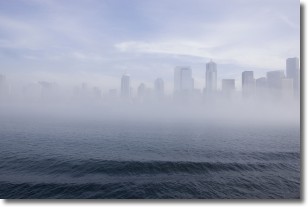
Weather Topic: What is Fog?
Home - Education - Cloud Types - Fog
 Next Topic: Fractus Clouds
Fog is technically a type of stratus cloud, which lies along the
ground and obscures visibility.
It is usually created when humidity in the air condenses into tiny water droplets.
Because of this, some places are more prone to foggy weather, such as regions
close to a body of water.
Fog is similar to mist; both are the appearance of water droplets suspended in
the air, but fog is the term applied to the condition when visibility is less than 1 km.
Next Topic: Fractus Clouds
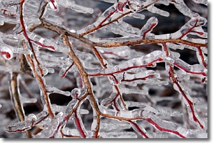
Weather Topic: What is Freezing Rain?
Home - Education - Precipitation - Freezing Rain
 Next Topic: Graupel
Freezing rain is a condition where precipitation which has fallen in the form of
water droplets reaches temperatures which are below freezing and freezes upon
coming into contact
with surface objects. The result of this precipitation is a glaze of ice which
can be damaging to plants and man-made structures. A severe onset of freezing
rain which results in a very thick glaze of ice is known as an ice storm.
Next Topic: Graupel
Current conditions powered by WeatherAPI.com


