Weather Alert in California
High Surf Advisory High Wind Watch Wind Advisory Winter Storm Watch
Winter Storm Warning issued February 14 at 12:28PM PST until February 18 at 4:00PM PST by NWS Eureka CA
AREAS AFFECTED: Northern Trinity; Southern Trinity
DESCRIPTION: * WHAT...Heavy snow expected for elevations above 5000 feet through Monday, then above 2000 feet Monday night. Total snow accumulation between 6 to 10 inches possible above 2000 feet. Total snow accumulations between 1 and 2.5 feet possible for elevations above 3000 feet. Winds gusting as high as 35 mph. * WHERE...Trinity County. * WHEN...From 7 AM Sunday to 4 PM PST Wednesday. * IMPACTS...Travel could be very difficult to impossible. Tire chains may be necessary if travelling through mountain passes. * ADDITIONAL DETAILS...Snow levels will remain above 5000 to 4500 feet Sunday through Monday, dropping to 2000 feet Monday night into Tuesday. There is a potential for snow levels as low as 1500 feet with the heaviest snowfall. The heaviest snowfall rates are expected late Monday through Tuesday morning.
INSTRUCTION: If you must travel, keep an extra flashlight, food, and water in your vehicle in case of an emergency. The latest road conditions for the state you are calling from can be obtained by calling 5 1 1.
Want more detail? Get the Complete 7 Day and Night Detailed Forecast!
Current U.S. National Radar--Current
The Current National Weather Radar is shown below with a UTC Time (subtract 5 hours from UTC to get Eastern Time).

National Weather Forecast--Current
The Current National Weather Forecast and National Weather Map are shown below.

National Weather Forecast for Tomorrow
Tomorrow National Weather Forecast and Tomorrow National Weather Map are show below.

North America Water Vapor (Moisture)
This map shows recent moisture content over North America. Bright and colored areas show high moisture (ie, clouds); brown indicates very little moisture present; black indicates no moisture.

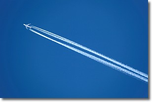
Weather Topic: What are Contrails?
Home - Education - Cloud Types - Contrails
 Next Topic: Cumulonimbus Clouds
A contrail is an artificial cloud, created by the passing of an
aircraft.
Contrails form because water vapor in the exhaust of aircraft engines is suspended
in the air under certain temperatures and humidity conditions. These contrails
are called exhaust contrails.
Another type of contrail can form due to a temporary reduction in air pressure
moving over the plane's surface, causing condensation.
These are called aerodynamic contrails.
When you can see your breath on a cold day, it is also because of condensation.
The reason contrails last longer than the condensation from your breath is
because the water in contrails freezes into ice particles.
Next Topic: Cumulonimbus Clouds
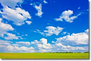
Weather Topic: What are Cumulus Clouds?
Home - Education - Cloud Types - Cumulus Clouds
 Next Topic: Drizzle
Cumulus clouds are fluffy and textured with rounded tops, and
may have flat bottoms. The border of a cumulus cloud
is clearly defined, and can have the appearance of cotton or cauliflower.
Cumulus clouds form at low altitudes (rarely above 2 km) but can grow very tall,
becoming cumulus congestus and possibly the even taller cumulonimbus clouds.
When cumulus clouds become taller, they have a greater chance of producing precipitation.
Next Topic: Drizzle
Current conditions powered by WeatherAPI.com


