Weather Alert in California
Winter Storm Watch issued February 13 at 11:44AM PST until February 18 at 10:00AM PST by NWS Eureka CA
AREAS AFFECTED: Northwestern Mendocino Interior; Northeastern Mendocino Interior; Northern Lake County; Southern Lake County
DESCRIPTION: * WHAT...Heavy snow possible elevations above 2500 feet. Total snow accumulations up to 5 inches possible. * WHERE...Lake County, and Northern Mendocino Interior. * WHEN...From Monday evening through Wednesday morning. * IMPACTS...Travel could be very difficult. The hazardous conditions could impact the Tuesday morning and evening commutes. * ADDITIONAL DETAILS...The heaviest snowfall rates are expected early Tuesday morning. There is the potential for snow level as low as 2000 feet with the heaviest snowfall amounts.
INSTRUCTION: Monitor the latest forecasts for updates on this situation.
Want more detail? Get the Complete 7 Day and Night Detailed Forecast!
Current U.S. National Radar--Current
The Current National Weather Radar is shown below with a UTC Time (subtract 5 hours from UTC to get Eastern Time).

National Weather Forecast--Current
The Current National Weather Forecast and National Weather Map are shown below.

National Weather Forecast for Tomorrow
Tomorrow National Weather Forecast and Tomorrow National Weather Map are show below.

North America Water Vapor (Moisture)
This map shows recent moisture content over North America. Bright and colored areas show high moisture (ie, clouds); brown indicates very little moisture present; black indicates no moisture.

Weather Topic: What is Freezing Rain?
Home - Education - Precipitation - Freezing Rain
 Next Topic: Graupel
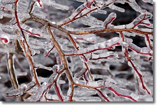
Freezing rain is a condition where precipitation which has fallen in the form of
water droplets reaches temperatures which are below freezing and freezes upon
coming into contact
with surface objects. The result of this precipitation is a glaze of ice which
can be damaging to plants and man-made structures. A severe onset of freezing
rain which results in a very thick glaze of ice is known as an ice storm.
Next Topic: Graupel
Weather Topic: What is Hail?
Home - Education - Precipitation - Hail
 Next Topic: Hole Punch Clouds
Hail is a form of precipitation which is recognized by large solid balls or
clumps of ice. Hail is created by thunderstorm clouds with strong updrafts of wind.
As the hailstones remain in the updraft, ice is deposited onto them until their
weight becomes heavy enough for them to fall to the earth's surface.
Hail storms can cause significant damage to crops, aircrafts, and man-made structures,
despite the fact that the duration is usually less than ten minutes.
Next Topic: Hole Punch Clouds
Current conditions powered by WeatherAPI.com


