Weather Alert in California
Winter Storm Watch issued February 13 at 11:06AM PST until February 18 at 10:00PM PST by NWS Reno NV
AREAS AFFECTED: Mono
DESCRIPTION: * WHAT...Heavy snow. Snow accumulations between 15 to 30 inches west of Highway 395, with 2 to 4 feet in the high Sierra. This includes locations such as Conway Summit, Lee Vining, June Lake, Mammoth Lakes, and Toms Place. 8 to 18 inches near and east of Highway 395, such as Bridgeport, Walker, Bodie, and Benton. Lesser amounts of 2 to 4 inches for the Chalfant Valley. Winds gusting 35 to 45 mph, with up to 65 mph for wind prone locations along US-395. Sierra ridge gusts over 100 mph. * WHERE...Mono County. * WHEN...From Sunday evening through Wednesday evening. * IMPACTS...Travel could be very difficult to impossible with periods of white out conditions. Very strong winds could cause damage to trees and power lines. * ADDITIONAL DETAILS...Conditions will rapidly deteriorate Monday evening with the highest snowfall rates anticipated Monday night through Tuesday evening.
INSTRUCTION: Monitor the latest forecasts for updates on this situation. Persons should consider delaying all travel. Motorists should use extreme caution if travel is absolutely necessary.
Want more detail? Get the Complete 7 Day and Night Detailed Forecast!
Current U.S. National Radar--Current
The Current National Weather Radar is shown below with a UTC Time (subtract 5 hours from UTC to get Eastern Time).

National Weather Forecast--Current
The Current National Weather Forecast and National Weather Map are shown below.

National Weather Forecast for Tomorrow
Tomorrow National Weather Forecast and Tomorrow National Weather Map are show below.

North America Water Vapor (Moisture)
This map shows recent moisture content over North America. Bright and colored areas show high moisture (ie, clouds); brown indicates very little moisture present; black indicates no moisture.

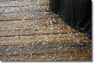
Weather Topic: What is Sleet?
Home - Education - Precipitation - Sleet
 Next Topic: Snow
Sleet is a form of precipitation in which small ice pellets are the primary
components. These ice pellets are smaller and more translucent than hailstones,
and harder than graupel. Sleet is caused by specific atmospheric conditions and
therefore typically doesn't last for extended periods of time.
The condition which leads to sleet formation requires a warmer body of air to be
wedged in between two sub-freezing bodies of air. When snow falls through a warmer
layer of air it melts, and as it falls through the next sub-freezing body of air
it freezes again, forming ice pellets known as sleet. In some cases, water
droplets don't have time to freeze before reaching the surface and the result is
freezing rain.
Next Topic: Snow
Weather Topic: What are Stratocumulus Clouds?
Home - Education - Cloud Types - Stratocumulus Clouds
 Next Topic: Stratus Clouds
Stratocumulus clouds are similar to altocumulus clouds in their
fluffy appearance, but have a slightly darker shade due to their additional mass.
A good way to distinguish the two cloud types is to hold your hand out and measure
the size of an individual cloud; if it is the size of your thumb it is generally
an altocumulus cloud, if it is the size of your hand it is generally a
stratocumulus cloud.
It is uncommon for stratocumulus clouds to produce precipitation, but if they do
it is usually a light rain or snow.
Next Topic: Stratus Clouds
Current conditions powered by WeatherAPI.com


