Weather Alert in California
Winter Storm Watch issued February 13 at 11:06AM PST until February 18 at 10:00PM PST by NWS Reno NV
AREAS AFFECTED: Greater Lake Tahoe Area; Greater Lake Tahoe Area
DESCRIPTION: * WHAT...Heavy snow. Snow accumulations between 18 to 30 inches in the Tahoe Basin, highest on the west shore, and much of Alpine County. This includes Tahoe City, Homewood, South Lake Tahoe, Carnelian Bay, Hope Valley, and Markleeville. Sierra snow accumulation of 2 to 5 feet. Winds gusting 35 to 45 mph in valleys, with Sierra ridge gusts over 100 mph. * WHERE...Greater Lake Tahoe Area. * WHEN...From Sunday evening through Wednesday evening. * IMPACTS...Travel could be very difficult to impossible with periods of white out conditions. Very strong winds could cause damage to trees and power lines. * ADDITIONAL DETAILS...The highest snowfall rates will be late Monday afternoon through Tuesday afternoon.
INSTRUCTION: Monitor the latest forecasts for updates on this situation. Persons should consider delaying all travel. Motorists should use extreme caution if travel is absolutely necessary.
Want more detail? Get the Complete 7 Day and Night Detailed Forecast!
Current U.S. National Radar--Current
The Current National Weather Radar is shown below with a UTC Time (subtract 5 hours from UTC to get Eastern Time).

National Weather Forecast--Current
The Current National Weather Forecast and National Weather Map are shown below.

National Weather Forecast for Tomorrow
Tomorrow National Weather Forecast and Tomorrow National Weather Map are show below.

North America Water Vapor (Moisture)
This map shows recent moisture content over North America. Bright and colored areas show high moisture (ie, clouds); brown indicates very little moisture present; black indicates no moisture.

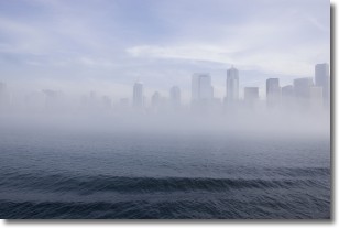
Weather Topic: What is Fog?
Home - Education - Cloud Types - Fog
 Next Topic: Fractus Clouds
Fog is technically a type of stratus cloud, which lies along the
ground and obscures visibility.
It is usually created when humidity in the air condenses into tiny water droplets.
Because of this, some places are more prone to foggy weather, such as regions
close to a body of water.
Fog is similar to mist; both are the appearance of water droplets suspended in
the air, but fog is the term applied to the condition when visibility is less than 1 km.
Next Topic: Fractus Clouds
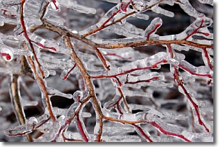
Weather Topic: What is Freezing Rain?
Home - Education - Precipitation - Freezing Rain
 Next Topic: Graupel
Freezing rain is a condition where precipitation which has fallen in the form of
water droplets reaches temperatures which are below freezing and freezes upon
coming into contact
with surface objects. The result of this precipitation is a glaze of ice which
can be damaging to plants and man-made structures. A severe onset of freezing
rain which results in a very thick glaze of ice is known as an ice storm.
Next Topic: Graupel
Current conditions powered by WeatherAPI.com


