Weather Alert in Georgia
Flood Warning issued June 17 at 10:56AM EDT until June 19 at 8:00AM EDT by NWS Charleston SC
AREAS AFFECTED: Tattnall, GA; Toombs, GA
DESCRIPTION: * WHAT...Minor flooding is forecast. * WHERE...Ohoopee River near Reidsville. * WHEN...From Wednesday morning to Thursday morning. * IMPACTS...At 11.0 feet, water enters the back yards of some homes in the Joy Bluff community. * ADDITIONAL DETAILS... - At 1000 AM EDT Tuesday, the stage was 10.3 feet. - Forecast...The river is expected to rise to a crest of 11.0 feet Wednesday morning. It will then fall below flood stage Wednesday evening. - Flood stage is 11.0 feet.
INSTRUCTION: N/A
Want more detail? Get the Complete 7 Day and Night Detailed Forecast!
Current U.S. National Radar--Current
The Current National Weather Radar is shown below with a UTC Time (subtract 5 hours from UTC to get Eastern Time).

National Weather Forecast--Current
The Current National Weather Forecast and National Weather Map are shown below.

National Weather Forecast for Tomorrow
Tomorrow National Weather Forecast and Tomorrow National Weather Map are show below.

North America Water Vapor (Moisture)
This map shows recent moisture content over North America. Bright and colored areas show high moisture (ie, clouds); brown indicates very little moisture present; black indicates no moisture.

Weather Topic: What are Cirrus Clouds?
Home - Education - Cloud Types - Cirrus Clouds
 Next Topic: Condensation
Cirrus clouds are high-level clouds that occur above 20,000 feet
and are composed mainly of ice crystals.
They are thin and wispy in appearance.
What do they indicate?
They are often the first sign of an approaching storm.
Next Topic: Condensation
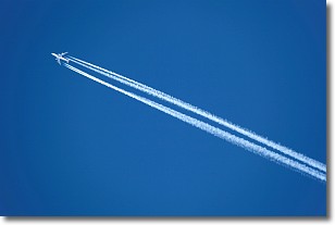
Weather Topic: What are Contrails?
Home - Education - Cloud Types - Contrails
 Next Topic: Cumulonimbus Clouds
A contrail is an artificial cloud, created by the passing of an
aircraft.
Contrails form because water vapor in the exhaust of aircraft engines is suspended
in the air under certain temperatures and humidity conditions. These contrails
are called exhaust contrails.
Another type of contrail can form due to a temporary reduction in air pressure
moving over the plane's surface, causing condensation.
These are called aerodynamic contrails.
When you can see your breath on a cold day, it is also because of condensation.
The reason contrails last longer than the condensation from your breath is
because the water in contrails freezes into ice particles.
Next Topic: Cumulonimbus Clouds
Current conditions powered by WeatherAPI.com


