Weather Alert in Michigan
Air Quality Alert issued June 16 at 12:24PM EDT by NWS Grand Rapids MI
AREAS AFFECTED: Muskegon; Ottawa; Kent; Allegan; Van Buren
DESCRIPTION: Air Quality Advisory for June 17, 2025 The Michigan Department of Environment, Great Lakes, and Energy (EGLE) has declared an Air Quality Advisory for June 17 for elevated levels of ozone in several western lake shore counties. Pollutants within those areas are expected to be in the Unhealthy for Sensitive Groups (USG, Orange AQI) range. The Air Quality Advisory is in effect for the following Michigan counties: Allegan, Kent, Muskegon, Ottawa, and Van Buren All signs point towards the likely development of elevated ozone along the several lake shore counties. Elements such as wind direction, temperature, dew points, upper air conditions all point towards the likelihood that could see ozone concentration in the Unhealthy for Sensitive Groups (USG) range along those counties. Cloud cover is uncertain during the peak heating hours of the day, but enough sun will likely be present to trigger the photochemical reactions necessary to generate ozone. It is recommended that, when possible, you avoid strenuous outdoor activities, especially those with respiratory diseases such as asthma. People and businesses are urged to avoid activities which can lead to ozone formation. These activities include: refueling vehicles or topping off when refueling, using gasoline powered lawn equipment, using charcoal lighter fluid. Positive activities include: Driving less, telecommuting, walking or bike riding, delaying or combining errands, using water-based paints. For further information, please see EPAs Air Now site for up-to- date air quality data: https://www.airnow.gov/
INSTRUCTION: N/A
Want more detail? Get the Complete 7 Day and Night Detailed Forecast!
Current U.S. National Radar--Current
The Current National Weather Radar is shown below with a UTC Time (subtract 5 hours from UTC to get Eastern Time).

National Weather Forecast--Current
The Current National Weather Forecast and National Weather Map are shown below.

National Weather Forecast for Tomorrow
Tomorrow National Weather Forecast and Tomorrow National Weather Map are show below.

North America Water Vapor (Moisture)
This map shows recent moisture content over North America. Bright and colored areas show high moisture (ie, clouds); brown indicates very little moisture present; black indicates no moisture.

Weather Topic: What is Precipitation?
Home - Education - Precipitation - Precipitation
 Next Topic: Rain
Precipitation can refer to many different forms of water that
may fall from clouds. Precipitation occurs after a cloud has become saturated to
the point where its water particles are more dense than the air below the cloud.
In most cases, precipitation will reach the ground, but it is not uncommon for
precipitation to evaporate before it reaches the earth's surface.
When precipitation evaporates before it contacts the ground it is called Virga.
Graupel, hail, sleet, rain, drizzle, and snow are forms of precipitation, but fog
and mist are not considered precipitation because the water vapor which
constitutes them isn't dense enough to fall to the ground.
Next Topic: Rain
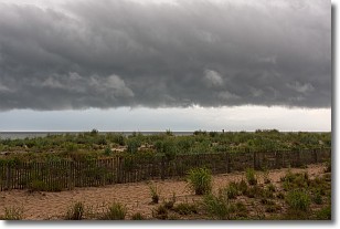
Weather Topic: What are Shelf Clouds?
Home - Education - Cloud Types - Shelf Clouds
 Next Topic: Sleet
A shelf cloud is similar to a wall cloud, but forms at the front
of a storm cloud, instead of at the rear, where wall clouds form.
A shelf cloud is caused by a series of events set into motion by the advancing
storm; first, cool air settles along the ground where precipitation has just fallen.
As the cool air is brought in, the warmer air is displaced, and rises above it,
because it is less dense. When the warmer air reaches the bottom of the storm cloud,
it begins to cool again, and the resulting condensation is a visible shelf cloud.
Next Topic: Sleet
Current conditions powered by WeatherAPI.com


