Weather Alert in Utah
Winter Storm Warning issued February 16 at 2:10PM MST until February 19 at 5:00AM MST by NWS Salt Lake City UT
AREAS AFFECTED: Wasatch Back; Wasatch Mountains I-80 North; Wasatch Mountains South of I-80; Western Uinta Mountains
DESCRIPTION: * WHAT...Heavy snow expected. Total snow accumulations between 1 and 2 feet with locally higher accumulations up to 3 feet across the Upper Cottonwoods and Bear River Mountains. Winds gusting as high as 45 mph in the Wasatch Back and 60 mph in the mountains through Monday night. * WHERE...The Wasatch Mountains, Wasatch Back, and Western Uinta Mountains. * WHEN...From 5 PM this afternoon to 5 AM MST Thursday. * IMPACTS...Winter driving conditions can be expected on all mountain routes. Traction restrictions are likely. * ADDITIONAL DETAILS...A period of heavy snow is expected Monday night, with snowfall continuing into Tuesday afternoon. A brief lull is expected Tuesday afternoon before ramping up again Tuesday evening. Another round of heavy snow is expected Wednesday. Very strong winds, peaking Monday night, will persist through at least Wednesday.
INSTRUCTION: If you must travel, keep an extra flashlight, food, and water in your vehicle in case of an emergency. For winter road conditions from the Utah Department of Transportation, visit http://www.udottraffic.utah.gov. For graphical depictions of the snowfall forecast, including Official NWS Forecast, High End Amount, and Low End Amount, visit weather.gov/slc/winter.
Want more detail? Get the Complete 7 Day and Night Detailed Forecast!
Current U.S. National Radar--Current
The Current National Weather Radar is shown below with a UTC Time (subtract 5 hours from UTC to get Eastern Time).

National Weather Forecast--Current
The Current National Weather Forecast and National Weather Map are shown below.

National Weather Forecast for Tomorrow
Tomorrow National Weather Forecast and Tomorrow National Weather Map are show below.

North America Water Vapor (Moisture)
This map shows recent moisture content over North America. Bright and colored areas show high moisture (ie, clouds); brown indicates very little moisture present; black indicates no moisture.

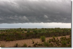
Weather Topic: What are Shelf Clouds?
Home - Education - Cloud Types - Shelf Clouds
 Next Topic: Sleet
A shelf cloud is similar to a wall cloud, but forms at the front
of a storm cloud, instead of at the rear, where wall clouds form.
A shelf cloud is caused by a series of events set into motion by the advancing
storm; first, cool air settles along the ground where precipitation has just fallen.
As the cool air is brought in, the warmer air is displaced, and rises above it,
because it is less dense. When the warmer air reaches the bottom of the storm cloud,
it begins to cool again, and the resulting condensation is a visible shelf cloud.
Next Topic: Sleet
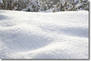
Weather Topic: What is Snow?
Home - Education - Precipitation - Snow
 Next Topic: Stratocumulus Clouds
Snow is precipitation taking the form of ice crystals. Each ice crystal, or snowflake,
has unique characteristics, but all of them grow in a hexagonal structure.
Snowfall can last for sustained periods of time and result in significant buildup
of snow on the ground.
On the earth's surface, snow starts out light and powdery, but as it begins to melt
it tends to become more granular, producing small bits of ice which have the consistency of
sand. After several cycles of melting and freezing, snow can become very dense
and ice-like, commonly known as snow pack.
Next Topic: Stratocumulus Clouds
Current conditions powered by WeatherAPI.com


