Weather Alert in New Jersey
Coastal Flood Advisory issued August 22 at 4:52AM EDT until August 22 at 11:00PM EDT by NWS Mount Holly NJ
AREAS AFFECTED: Eastern Monmouth
DESCRIPTION: * WHAT...For the Coastal Flood Advisory, up to one foot of inundation above ground level in low-lying areas near shorelines and tidal waterways. For the High Surf Advisory, large breaking waves of up to 5 feet in the surf zone. For the High Rip Current Risk, dangerous rip currents. * WHERE...Eastern Monmouth. * WHEN...For the Coastal Flood Advisory, until 11 PM EDT this evening. For the High Surf Advisory, until 8 PM EDT this evening. For the High Rip Current Risk, through Saturday evening. * IMPACTS...At this level, flooding begins on the most vulnerable roads in coastal and bayside communities, and along inland tidal waterways. Some partial or full road closures are possible. Dangerous swimming and surfing conditions and localized beach erosion. Rip currents can sweep even the best swimmers away from shore into deeper water.
INSTRUCTION: A Coastal Flood Advisory means that minor tidal flooding is expected. Minor tidal flooding often results in some road closures. Usually, the most vulnerable roadways will flood. Do not leave your vehicle at a location that is prone to tidal flooding. Do not drive your vehicle through flood waters. The water may be deeper than you think it is. You will be putting yourself in danger and your vehicle may be damaged, leading to costly repairs. Visit the Advanced Hydrologic Prediction Service at water.weather.gov/ahps for additional water level and flood impact information for your local tide gauge. Inexperienced swimmers should remain out of the water due to dangerous surf conditions. Always obey posted Beach Flags. If you enter the surf zone, always have a floatation device with you and swim near a lifeguard if possible. If caught in a rip current, relax and float and do not swim against the current. If able, swim parallel to the shoreline. If unable to escape, face the shore and call or wave for help.
Want more detail? Get the Complete 7 Day and Night Detailed Forecast!
Current U.S. National Radar--Current
The Current National Weather Radar is shown below with a UTC Time (subtract 5 hours from UTC to get Eastern Time).

National Weather Forecast--Current
The Current National Weather Forecast and National Weather Map are shown below.

National Weather Forecast for Tomorrow
Tomorrow National Weather Forecast and Tomorrow National Weather Map are show below.

North America Water Vapor (Moisture)
This map shows recent moisture content over North America. Bright and colored areas show high moisture (ie, clouds); brown indicates very little moisture present; black indicates no moisture.

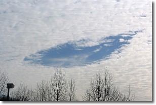
Weather Topic: What are Hole Punch Clouds?
Home - Education - Cloud Types - Hole Punch Clouds
 Next Topic: Mammatus Clouds
A hole punch cloud is an unusual occurrence when a disk-shaped
hole appears in a cirrostratus, cirrocumulus, or altocumulus cloud.
When part of the cloud forms ice crystals, water droplets in the surrounding area
of the cloud evaporate. The effect of this process produces a large elliptical
gap in the cloud. The hole punch cloud formation is rare, but it is not specific
to any geographic area.
Other names which have been used to describe this phenomena include fallstreak hole,
skypunch, and cloud hole.
Next Topic: Mammatus Clouds
Weather Topic: What are Nimbostratus Clouds?
Home - Education - Cloud Types - Nimbostratus Clouds
 Next Topic: Precipitation
A nimbostratus cloud is similar to a stratus cloud in its formless,
smooth appearance. However, a nimbostratus cloud is darker than a stratus cloud,
because it is thicker.
Unlike a stratus cloud, a nimbostratus cloud typically brings with it the threat
of moderate to heavy precipitation. In some cases, the precipitation may evaporate
before reaching the ground, a phenomenon known as virga.
Next Topic: Precipitation
Current conditions powered by WeatherAPI.com


