Weather Alert in Nebraska
Fire Weather Watch issued March 17 at 2:08AM CDT until March 18 at 8:00PM CDT by NWS North Platte NE
AREAS AFFECTED: Eastern Panhandle/Crescent Lake NWR; Sandhills/Valentine NWR/Nebraska National Forest; Frenchman Basin
DESCRIPTION: ...NEW FIRE WEATHER WATCH ISSUED FOR PORTIONS OF WESTERN NEBRASKA WEDNESDAY IN ADDITION TO RED FLAG WARNING IN PLACE FOR TUESDAY... ...FIRE WEATHER WATCH IN EFFECT FROM WEDNESDAY AFTERNOON THROUGH WEDNESDAY EVENING FOR STRONG WINDS AND LOW RELATIVE HUMIDITY FOR WEST CENTRAL NEBRASKA... The National Weather Service in North Platte has issued a Fire Weather Watch for strong winds and low relative humidity, which is in effect from Wednesday afternoon through Wednesday evening. * AFFECTED AREA...Fire Weather Zone 204 Eastern Panhandle/Crescent Lake NWR, Fire Weather Zone 206 Sandhills/Valentine NWR/Nebraska National Forest and Fire Weather Zone 210 Frenchman Basin. * TIMING...For the Red Flag Warning: 11 AM CDT /10 AM MDT/ to 9 PM CDT /8 PM MDT/ Tuesday. For the Fire Weather Watch: 12 PM CDT /11 AM MDT/ to 8 PM CDT /7 PM MDT/ Wednesday * WINDS...Northwest 20 to 30 mph with gusts up to 45 mph Tuesday. Northwest 10 to 20 mph with gusts up to 30 mph Wednesday. * RELATIVE HUMIDITY...As low as 20 percent Tuesday. As low as 15 percent Wednesday. * TEMPERATURES...Upper 60s to middle 70s Tuesday. Upper 70s to lower 80s Wednesday. * LIGHTNING...None expected either day. * IMPACTS...Any fire starts will have a high potential to spread rapidly and will be difficult to control.
INSTRUCTION: A Red Flag Warning means that critical fire weather conditions are either occurring now, or will shortly. A combination of strong winds, low relative humidity, and warm temperatures can contribute to extreme fire behavior. A Fire Weather Watch means that critical fire weather conditions are forecast to occur. Listen for later forecasts and possible Red Flag Warnings.
Want more detail? Get the Complete 7 Day and Night Detailed Forecast!
Current U.S. National Radar--Current
The Current National Weather Radar is shown below with a UTC Time (subtract 5 hours from UTC to get Eastern Time).

National Weather Forecast--Current
The Current National Weather Forecast and National Weather Map are shown below.

National Weather Forecast for Tomorrow
Tomorrow National Weather Forecast and Tomorrow National Weather Map are show below.

North America Water Vapor (Moisture)
This map shows recent moisture content over North America. Bright and colored areas show high moisture (ie, clouds); brown indicates very little moisture present; black indicates no moisture.

Weather Topic: What is Condensation?
Home - Education - Precipitation - Condensation
 Next Topic: Contrails
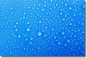
Condensation is the process which creates clouds, and therefore
it is a crucial process in the water cycle.
Condensation is the change of matter from a state of gas into a state of liquid,
and it happens because water molecules release heat into the atmosphere and
become organized into a more closely packed structure, what we might see as
water droplets.
Water is always present in the air around us as a vapor, but it's too small for
us to see. When water undergoes the process of condensation it becomes organized
into visible water droplets. You've probably seen condensation happen before on the
surface of a cold drink!
Next Topic: Contrails
Weather Topic: What are Cumulonimbus Clouds?
Home - Education - Cloud Types - Cumulonimbus Clouds
 Next Topic: Cumulus Clouds
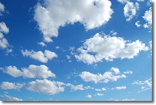
The final form taken by a growing cumulus cloud is the
cumulonimbus cloud, which is very tall and dense.
The tower of a cumulonimbus cloud can soar 23 km into the atmosphere, although
most commonly they stop growing at an altitude of 6 km.
Even small cumulonimbus clouds appear very large in comparison to other cloud types.
They can signal the approach of stormy weather, such as thunderstorms or blizzards.
Next Topic: Cumulus Clouds
Current conditions powered by WeatherAPI.com


